Wolstonbury Hill
| Site of Special Scientific Interest | |
 | |
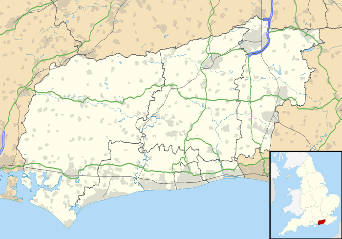 Location within West Sussex | |
| Area of Search | West Sussex |
|---|---|
| Grid reference | TQ282140 |
| Coordinates | 50°54′40″N 0°10′32″W / 50.911099°N 0.175532°WCoordinates: 50°54′40″N 0°10′32″W / 50.911099°N 0.175532°W |
| Interest | Biological |
| Area | 58.6 ha (145 acres) |
| Notification | 1954 |
| Natural England website | |
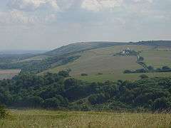
Wolstonbury Hill is a chalk prominence in the South Downs National Park, approximately 10 kilometres (6.2 mi) north of Brighton and 1.5 kilometres (0.93 mi) west of Clayton, in the parish of Pyecombe, West Sussex, England. It lies 2.5 kilometres (1.6 mi) south of Hurstpierpoint, a village mentioned in the Domesday Book of 1085.
Description
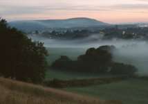
Rising to a maximum height of 206 metres (676 ft), Wolstonbury projects into the Weald from the main ridge of the South Downs giving views of both the Downs and the Weald. Views across the Weald to the north are panoramic, to the east are the Clayton Windmills and Ditchling Beacon beyond. Hollingbury is prominent to the southeast. Looking west one can see Newtimber Hill, West Hill with Devils Dyke just beyond, further out Chanctonbury Ring is clearly visible.

Wolstonbury, owned and maintained by the National Trust, is listed as a Scheduled Monument.
Access
No roads or car parks lie close to the summit so visitors have to ascend on foot or by mountain bike.
Geology
South of Hurstpierpoint ridge, the clay vale lies beneath the jutting profile and complex scarp and foot of Wolstonbury Hill.
The approach from the north is characterised by a network of linked or closely spaced woodlands (some parts ancient) centred on the designed landscape at Danny House.
Flora and fauna
There is a great diversity of plants and insects that can be found on the hill, emphasising that chalk grassland, although it is a man-made habitat, it is also one of the rarest and most diverse habitats in the world. The area has been designated a Site of Special Scientific Interest.[1] Present ground conditions consist of grassland/pasture with a minimal to dense covering of scrub.
The base of the hill is shrouded with beech woods.
Wolstonbury also has some rare (for Sussex) orchids [2] along with a profusion of more common varieties.

Archeology and history
The remains at the site include a 2.2-hectare (5.4-acre) early Bronze Age enclosure now referred to as Wolstonbury C.[3] A possible inner enclosure known as Wolstonbury A appears to be older, due to it being overlain by C. Wolstonbury B is another possible enclosure sandwiched between A and C, its presence indicated by a survey conducted in 1994 by the Royal Commission on the Historical Monuments of England. Excavations done by Bournemouth University in 1995 suggest that Wolstonbury A and B may be field lynchets.[4]
Skeletons were reportedly unearthed during flint digging operations begun in 1765. This digging continued until the mid-19th century, resulting in extensive damage to the site. Unknown quantities of Neolithic and early Bronze Age flintwork were discovered in a 1929 dig as well as "Romano-British" pottery, animal bones, and hammerstones.[5]
Danny House

Danny House, which is at the northern foot of Wolstonbury Hill, is a large house set in extensive parkland. The medieval Park of Danny was enclosed by the last Sir Simon de Pierpoint in 1343. In 1652 Danny Great Park was 54 hectares (135 acres) with arable land and meadow amounting to about 170 hectares (420 acres). The parkland still contains large, noble oaks of varying ages and growth patterns and is used today for a variety of recreational activities.
The present house was built in 1593–95 by George Goring, slightly to the east of an older house. Danny House has two main fronts: the east (16th Century) and the south (early Georgian). The brick-built east frontage is monumental, and the south front stately. The building as a whole is prominent in views from the nearby downs. There is a well-preserved ice house in the grounds, and a Roman pavement has also been unearthed there.
On 13 October 1918 Danny House was the scene of a meeting of the Imperial War Cabinet, including David Lloyd George and Winston Churchill, and it was here that the decision was made to negotiate the armistice with Germany.
Traditions
On Ascension Day, every member of the nearby Hurstpierpoint College climbs Wolstonbury Hill. Once the whole school is assembled on top of the hill the choir sings the 17th century Hymnus Eucharisticus. After singing the hymn the Headmaster hands out the Lowe's Dole - money left by the first Headmaster, Canon Lowe, for the choir and sacristans.
Folklore
King Alfred is said to have fought on Wolstonbury Hill and the ten horseshoes which are on the Bull Hotel at Ditchling are said to have been cast by his ponies.[6]
References
- ↑ "SSSI Citation — Wolstonbury Hill" (PDF). Natural England. Retrieved 4 April 2009.
- ↑ http://www.southdownsonline.org/protecting/rte.asp?id=285
- ↑ "Introduction to Wolstonbury". Bournemouth University. Retrieved 2017-11-20.
- ↑ "Research by Bournemouth University - Wolstonbury Prehistoric Enclosures". Bournemouth University. Retrieved 2017-11-20.
- ↑ "Summary of Archaeological History - Wolstonbury". Bournemouth University. Retrieved 2017-11-20.
- ↑ Emslie, John Philipps (1915). Burne, C.S., ed. "Scraps of Folklore Collected by John Philipps Emslie". Folk-Lore. 26: 164.