Wingville, Oregon
| Wingville, Oregon | |
|---|---|
| Unincorporated community | |
 Wingville, Oregon  Wingville, Oregon | |
| Coordinates: 44°50′23″N 117°55′18″W / 44.83972°N 117.92167°WCoordinates: 44°50′23″N 117°55′18″W / 44.83972°N 117.92167°W | |
| Country | United States |
| State | Oregon |
| County | Baker |
| Elevation | 3,402 ft (1,037 m) |
| Time zone | UTC-8 (Pacific (PST)) |
| • Summer (DST) | UTC-7 (PDT) |
| Area code(s) | 458 and 541 |
| GNIS feature ID | 1129233[1] |
Wingville is an unincorporated community in Baker County, Oregon, United States.[1] Wingville lies at the intersection of Wingville Lane and Old Wingville Road northwest of Baker City and northeast of Pocahontas.[2]
The community's name stemmed from a derisive term for former soldiers of the Confederate States Army who had served during the American Civil War under Sterling Price, a major general, and who later emigrated to Oregon. Sometimes collectively referred to as a wing of Price's army, a group of them settled in Baker County after the war.[3]
Wingville had a post office from June 23, 1871, through July 1879. John R. McLain was the first postmaster.[3]
References
- 1 2 "Wingville". Geographic Names Information System. United States Geological Survey. November 28, 1980. Retrieved November 10, 2016.
- ↑ "Wingville". ACME Labs. Retrieved November 10, 2016 – via ACME mapper.
- 1 2 McArthur, Lewis A.; McArthur, Lewis L. (2003) [1928]. Oregon Geographic Names (7th ed.). Portland, Oregon: Oregon Historical Society Press. p. 1051. ISBN 978-0875952772.
Municipalities and communities of Baker County, Oregon, United States | ||
|---|---|---|
| Cities | 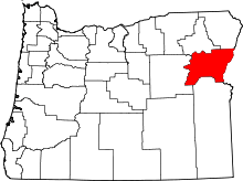 | |
| Unincorporated communities | ||
| Ghost towns | ||
| Footnotes |
| |
This article is issued from
Wikipedia.
The text is licensed under Creative Commons - Attribution - Sharealike.
Additional terms may apply for the media files.