Lime, Oregon
| Lime, Oregon | |
|---|---|
| Unincorporated community | |
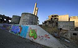 Abandoned cement plant at Lime | |
 Lime, Oregon  Lime, Oregon | |
| Coordinates: 44°24′24″N 117°18′41″W / 44.40667°N 117.31139°WCoordinates: 44°24′24″N 117°18′41″W / 44.40667°N 117.31139°W | |
| Country | United States |
| State | Oregon |
| County | Baker |
| Elevation | 2,234 ft (681 m) |
| Time zone | UTC-8 (Pacific (PST)) |
| • Summer (DST) | UTC-7 (PDT) |
| Area code(s) | 458 and 541 |
| GNIS feature ID | 1167713[1] |
Lime is an unincorporated community in Baker County, Oregon, United States,[1] 5 miles (8 km) north of Huntington on U.S. Route 30/Interstate 84. It is near the confluence of Marble Creek and the Burnt River on the Union Pacific Railroad. The Oregon Trail passes through Lime.[2]
The Lime post office was established in 1899.[3] The deposits of limestone in the area were manufactured into lime that supplied a large area of Eastern Oregon and western Idaho.[3][4] The Acme Cement Plaster Company built a plant at Lime in 1916 to produce plaster.[3] The Sun Portland Cement Company bought the plant in 1921 and built another facility for producing Portland cement.[3] In 1926, the company merged with Oregon Portland Cement Company from Portland; by the 1960s, the Lime facility produced 1,200,000 barrels a year.[3] In 1940, the community at its peak had a population of 18.[5] The town began to decline when the post office closed in 1964.
As the nearby limestone deposits were depleted, limestone was brought from the Nelson area near Durkee.[3] A new plant was built at Nelson in 1979 and the facility at Lime was closed in 1980.[3] Oregon Portland Cement Company merged with the Ash Grove Cement Company in 1983.[3][6]
In 1999, Baker County took possession of the site of the closed factory for back taxes. In 2018, the plant was scheduled for demolition. Demolition crews arrived in Lime in April 2018 to begin the work.[7] On June 15th, 2018, Daniel K. Allen passed Lime and most of the cement plant was still standing. However, passing the Lime cement plant on July 7th, 2018, Andrew Allen saw that it had been torn down.[8]
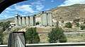 Lime Oregon cement plant 2018-06-15
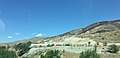 Lime Oregon razed cement plant 2018-07-07
See also
References
- 1 2 "Lime". Geographic Names Information System. United States Geological Survey. November 28, 1980. Retrieved November 15, 2016.
- ↑ Friedman, Ralph (2002) [1993]. The Other Side of Oregon (2nd ed.). Caldwell, Idaho: The Caxton Printers, Ltd. p. 46. ISBN 0-87004-352-8.
- 1 2 3 4 5 6 7 8 McArthur, Lewis A.; Lewis L. McArthur (2003) [1928]. Oregon Geographic Names (7th ed.). Portland, Oregon: Oregon Historical Society Press. p. 578. ISBN 0-87595-277-1.
- ↑ Bailey, Barbara Ruth (1982). Main Street: Northeastern Oregon. Oregon Historical Society. p. 32. ISBN 0-87595-073-6.
- ↑ Writers' Program of the Work Projects Administration in the State of Oregon (1940). Oregon: End of the Trail. American Guide Series. Portland, Oregon: Binfords & Mort. p. 251. OCLC 4874569.
- ↑ Merriman, Ed (November 27, 2009). "Durkee Doldrums: Locals Fear Ash Grove Layoffs Will Doom Businesses". Baker City Herald. Retrieved January 4, 2010.
- ↑ Collins, Chris. "Tumbling Down Contractor expects to finish demolition project by the first of June". Baker City Herald. Retrieved 1 August 2018.
- ↑ Personal correspondence to Daniel K. Allen, 7 July 2018.
External links
- Images of abandoned cement plant at Lime from Flickr
- Cockle, Richard (April 22, 2012). "Grand Idea to Turn Eastern Oregon Eyesore into Utopia Sparks Skepticism But Also Sliver of Hope". The Oregonian.
Municipalities and communities of Baker County, Oregon, United States | ||
|---|---|---|
| Cities | 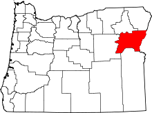 | |
| Unincorporated communities | ||
| Ghost towns | ||
| Footnotes |
| |