Pine, Oregon
| Pine, Oregon | |
|---|---|
| Unincorporated community | |
.jpg) Valley near Pine | |
 Pine, Oregon  Pine, Oregon | |
| Coordinates: 44°51′40″N 117°05′20″W / 44.861°N 117.089°WCoordinates: 44°51′40″N 117°05′20″W / 44.861°N 117.089°W | |
| Country | United States |
| State | Oregon |
| County | Baker |
| Elevation | 2,575 ft (785 m) |
| Time zone | UTC-8 (Pacific (PST)) |
| • Summer (DST) | UTC-7 (PDT) |
| ZIP code | 97834 |
| Area code(s) | 458 and 541 |
Pine is an unincorporated community in Baker County, Oregon, United States.[1][2] It lies along Oregon Route 86 about 2.3 miles (3.7 km) southeast of the city of Halfway, and beside Pine Creek, a tributary of the Snake River.[2]
References
- ↑ "Pine, Oregon". Oregon HomeTownLocator.
- 1 2 "Pine, Oregon". Geographic Names Information System. United States Geological Survey. November 28, 1980. Retrieved 2011-06-03.
Municipalities and communities of Baker County, Oregon, United States | ||
|---|---|---|
| Cities | 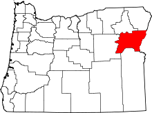 | |
| Unincorporated communities | ||
| Ghost towns | ||
| Footnotes |
| |
This article is issued from
Wikipedia.
The text is licensed under Creative Commons - Attribution - Sharealike.
Additional terms may apply for the media files.