Windsor Hills Historic District
|
Windsor Hills Historic District | |
 | |
   | |
| Location | Roughly bounded by Chelsea Terrace, Windsor Mill Rd., Talbot Rd., Westchester Rd., and Woodhaven Ave., Baltimore, Maryland |
|---|---|
| Coordinates | 39°18′59″N 76°41′11″W / 39.31639°N 76.68639°WCoordinates: 39°18′59″N 76°41′11″W / 39.31639°N 76.68639°W |
| Area | 170 acres (69 ha) |
| Architect | multiple |
| Architectural style | Shingle Style, Bungalow/craftsman, et al. |
| NRHP reference # | 02001610[1] |
| Added to NRHP | December 27, 2002 |
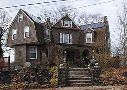
Windsor Hills Historic District is a national historic district in Baltimore, Maryland, United States. It is a cohesive residential suburb defined by rolling topography, winding, picturesque streets, stone garden walls, walks and private alley ways, early-20th century garden apartments, duplexes, and freestanding residences. Structures are predominantly of frame construction with locally quarried stone foundations. Windsor Hills developed over a period from about 1895 through 1929. The dominant styles include Shingle cottages, Dutch Colonial Revival houses, Foursquares, and Craftsman Bungalows.[2]
It was added to the National Register of Historic Places in 2002.[1]
References
- 1 2 National Park Service (2010-07-09). "National Register Information System". National Register of Historic Places. National Park Service.
- ↑ Kate Mahood and Moss Bittner (November 2001). "National Register of Historic Places Registration: Windsor Hills Historic District" (PDF). Maryland Historical Trust. Retrieved 2016-04-01.
External links
- Windsor Hills Historic District, Baltimore City, including photo from 2001, at Maryland Historical Trust
- Boundary Map of the Windsor Hills Historic District, Baltimore City, at Maryland Historical Trust
| Topics |  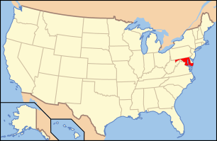 | |
|---|---|---|
| Lists by county | ||
| Lists by city | ||
| Other lists | ||
| ||
This article is issued from
Wikipedia.
The text is licensed under Creative Commons - Attribution - Sharealike.
Additional terms may apply for the media files.