Willhoit, Missouri
| Willhoit, Missouri | |
|---|---|
| Community | |
 Willhoit, Missouri Location of Willhoit, Missouri | |
| Coordinates: 36°41′1″N 92°30′20″W / 36.68361°N 92.50556°WCoordinates: 36°41′1″N 92°30′20″W / 36.68361°N 92.50556°W[1] | |
| Country | U. S. A. |
| State | Missouri |
| County | Ozark County |
| Elevation[1] | 270 m (890 ft) |
| Time zone | UTC-6 (CST) |
| • Summer (DST) | UTC-5 (CDT) |
Willhoit is an unincorporated community in Ozark County, Missouri.[2] It is located about eight miles north of Gainesville just east of Route 5 on a county road. It lies in a valley at the junction of Ludecker Creek and Barren Fork Creek.[1]
History
In 1908 a post office was established in the community and named Wilhoit after J. W. Wilhoit. Earlier, in 1895, the post office had been named Arp after a storekeeper. A later postmaster changed the spelling to Willhoit.[3] The post office closed in 1974.[4]
References
- 1 2 3 Wilhoit, Missouri, 7.5 Minute Topographic Quadrangle, USGS, 2004
- ↑ U.S. Geological Survey Geographic Names Information System: Willhoit, Missouri
- ↑ Ozark County Place Names, 1928-1945, State Historical Society of Missouri
- ↑ "Post Offices". Jim Forte Postal History. Retrieved 27 November 2016.
Municipalities and communities of Ozark County, Missouri, United States | ||
|---|---|---|
| Cities | 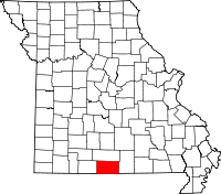 | |
| Villages | ||
| Townships |
| |
| CDPs | ||
| Other unincorporated communities | ||
| Ghost towns | ||
This article is issued from
Wikipedia.
The text is licensed under Creative Commons - Attribution - Sharealike.
Additional terms may apply for the media files.