Ocie, Missouri
| Ocie, Missouri | |
|---|---|
| Community | |
 Ocie, Missouri Location of Ocie, Missouri | |
| Coordinates: 36°33′33″N 92°45′33″W / 36.55917°N 92.75917°WCoordinates: 36°33′33″N 92°45′33″W / 36.55917°N 92.75917°W[1][2] | |
| Country | U. S. A. |
| State | Missouri |
| County | Ozark County |
| Elevation[1] | 227 m (745 ft) |
| Time zone | UTC-6 (CST) |
| • Summer (DST) | UTC-5 (CDT) |
Ocie is an unincorporated community in southwestern Ozark County, Missouri 0.66 miles (1.06 km) from the Taney County line. It is located 1.1 miles (1.8 km) south of U.S. Highway 160, 6.0 miles (9.7 km) WSW of Theodosia, Missouri. The townsite is in a valley 0.8 miles (1.3 km) north of the Lick Creek arm of Bull Shoals Lake.[2]
A post office was founded in 1907 and was named for resident Ocie Conklin.[3] The post office closed in 1967.[4] Its mail now comes from Theodosia.
References
- 1 2 Geographic Names Information System GNIS
- 1 2 Protem, Missouri, 7.5 Minute Topographic Quadrangle, USGS, 2004
- ↑ Moser, Arthur Paul, A Directory of Towns, Villages, and Hamlets Past and Present of Ozark County, Missouri,
- ↑ Ozark County Post offices
Municipalities and communities of Ozark County, Missouri, United States | ||
|---|---|---|
| Cities | 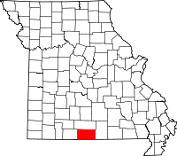 | |
| Villages | ||
| Townships |
| |
| CDPs | ||
| Other unincorporated communities | ||
| Ghost towns | ||
This article is issued from
Wikipedia.
The text is licensed under Creative Commons - Attribution - Sharealike.
Additional terms may apply for the media files.