Wikieup, Arizona
| Wikieup, Arizona | |
|---|---|
 | |
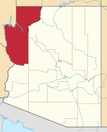
 Location of Wikieup in Mohave County, Arizona. | |
 Wikieup, Arizona Location in the United States | |
| Coordinates: 34°42′29″N 113°36′40″W / 34.70806°N 113.61111°WCoordinates: 34°42′29″N 113°36′40″W / 34.70806°N 113.61111°W | |
| Country | United States |
| State | Arizona |
| Counties | Mohave |
| Area[1] | |
| • Total | 4.44 sq mi (11.49 km2) |
| • Land | 4.44 sq mi (11.49 km2) |
| • Water | 0.00 sq mi (0.00 km2) |
| Elevation | 1,997 ft (609 m) |
| Population (2010) | |
| • Total | 6,363 |
| • Estimate (2016)[2] | N/A |
| Time zone | UTC-7 (MST) |
| ZIP code | 85360 |
| Area code(s) | 928 |
| FIPS code | 04-82880 |

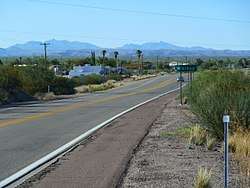
Sign at entrance to Wikieup
Wikieup is a small unincorporated community located on U.S. Route 93 in Mohave County, Arizona. It is located approximately 32 miles (51 km) south of Interstate 40 using U.S. Route 93 and approximately 124 miles (200 km) northwest of Phoenix, Arizona. In 2000, the population of Wikieup's ZCTA was 305.[3]
The lowest recorded temperature was 14 °F (−10 °C) in 1990, with a high of 119 °F (48 °C) recorded in 1995. Average lows for January range from 33 to 64 °F (1 to 18 °C), with highs in July ranging from 68 to 105 °F (20 to 41 °C). Rainfall averages 9.88 inches (251 mm) per year.
Demographics
| Historical population | |||
|---|---|---|---|
| Census | Pop. | %± | |
| U.S. Decennial Census[4] | |||
Attractions
- Wikieup Trading Post (Inn, Shop, Restaurant)
- Eat at Joe's Barbecue (Restaurant), now abandoned
- Cool Water Cafe (Restaurant, RV Park)
References
- ↑ "2016 U.S. Gazetteer Files". United States Census Bureau. Retrieved Jul 18, 2017.
- ↑ "Population and Housing Unit Estimates". Retrieved June 9, 2017.
- ↑ http://factfinder.census.gov/servlet/SAFFPopulation?_event=Search&_zip=85360
- ↑ "Census of Population and Housing". Census.gov. Retrieved June 4, 2016.
This article is issued from
Wikipedia.
The text is licensed under Creative Commons - Attribution - Sharealike.
Additional terms may apply for the media files.