Wiggensbach
| Wiggensbach | ||
|---|---|---|
 Wiggensbach | ||
| ||
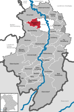
 Wiggensbach Location of Wiggensbach within Oberallgäu district  | ||
| Coordinates: 47°44′45″N 10°13′55″E / 47.74583°N 10.23194°ECoordinates: 47°44′45″N 10°13′55″E / 47.74583°N 10.23194°E | ||
| Country | Germany | |
| State | Bavaria | |
| Admin. region | Schwaben | |
| District | Oberallgäu | |
| Government | ||
| • Mayor | Thomas Eigstler (CSU) | |
| Area | ||
| • Total | 31.83 km2 (12.29 sq mi) | |
| Elevation | 870-1,077 m (−2,663 ft) | |
| Population (2017-12-31)[1] | ||
| • Total | 5,020 | |
| • Density | 160/km2 (410/sq mi) | |
| Time zone | CET/CEST (UTC+1/+2) | |
| Postal codes | 87487 | |
| Dialling codes | 08370 | |
| Vehicle registration | OA | |
| Website | www.wiggensbach.de | |
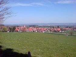
Wiggensbach is a municipality in Bavaria. It is situated about 7 kilometres west of Kempten, the next greater town.
Neighbour municipalities are Altusried in the north and Buchenberg in the south of the village. The municipality consists of Wiggensbach as the main village and Ermengerst and Westenried as two districts of Wiggensbach. There are furthermore 72 hamlets in the area of the municipality.
The height of the village is between 870 and 1.077 metres above sea level.
Partner township of Wiggensbach is Hattstatt in France, in 2003 the two communes commemorate 20th anniversary of the partnership.
First settlements in the nower boundaries of the municipality are documentated for the district Ermengerst in 1037, for Wiggensbach itself in 1182. In 1888 the Wiggensbach treasure was found, its coins were dated back to the first to third century A.C. This proves the early settlement of humans in the area.
References
- ↑ "Fortschreibung des Bevölkerungsstandes". Bayerisches Landesamt für Statistik und Datenverarbeitung (in German). September 2018.
