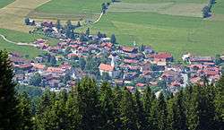
Rettenberg
| Rettenberg | ||
|---|---|---|
 Rettenberg | ||
| ||
 Rettenberg Location of Rettenberg within Oberallgäu district 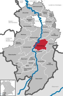 | ||
| Coordinates: 47°35′N 10°18′E / 47.583°N 10.300°ECoordinates: 47°35′N 10°18′E / 47.583°N 10.300°E | ||
| Country | Germany | |
| State | Bavaria | |
| Admin. region | Schwaben | |
| District | Oberallgäu | |
| Government | ||
| • Mayor | Oliver Kunz (since 1.May 2008) (CSU) | |
| Area | ||
| • Total | 60.08 km2 (23.20 sq mi) | |
| Elevation | 805 m (2,641 ft) | |
| Population (2017-12-31)[1] | ||
| • Total | 4,446 | |
| • Density | 74/km2 (190/sq mi) | |
| Time zone | CET/CEST (UTC+1/+2) | |
| Postal codes | 87549 | |
| Dialling codes | 08327 | |
| Vehicle registration | OA | |
| Website | www.rettenberg.de | |

Rettenberg is a municipality in the district of Oberallgäu in Bavaria in Germany.
Twin village
The village La Frénaye in Northern France (close to Le Havre).
Brewery-Village
Rettenberg is the southernmost village with breweries (Engelbräu and Zötlerbrauerei) in Germany. The Community use the slogan "Most South Brewery Village of Germany" for tourism.
References
- ↑ "Fortschreibung des Bevölkerungsstandes". Bayerisches Landesamt für Statistik und Datenverarbeitung (in German). September 2018.
| Wikimedia Commons has media related to Rettenberg. |
This article is issued from
Wikipedia.
The text is licensed under Creative Commons - Attribution - Sharealike.
Additional terms may apply for the media files.