Security-Widefield, Colorado
| Security-Widefield, Colorado | |
|---|---|
| Census-designated place | |
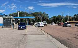 Looking northwest along Widefield Blvd. towards Fontaine Blvd. | |
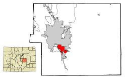 Location in El Paso County and the state of Colorado | |
 Security-Widefield, Colorado Location in the United States | |
| Coordinates: 38°44′41″N 104°43′24″W / 38.74472°N 104.72333°WCoordinates: 38°44′41″N 104°43′24″W / 38.74472°N 104.72333°W | |
| Country |
|
| State |
|
| County | El Paso County |
| Government | |
| • Type | Unincorporated community |
| Area | |
| • Total | 14.1 sq mi (36.6 km2) |
| • Land | 13.6 sq mi (35.3 km2) |
| • Water | 0.5 sq mi (1.3 km2) |
| Population (2013) | |
| • Total | 32,882 |
| • Density | 2,300/sq mi (900/km2) |
| Time zone | UTC-7 (MST) |
| • Summer (DST) | UTC-6 (MDT) |
| ZIP codes | Colorado Springs 80911, 80925, and 80928-80931 |
| Area code(s) | 719 |
| FIPS code | 08-68847 |
| GNIS feature ID | 2409300 |
Security-Widefield is a census-designated place (CDP) in El Paso County, Colorado, United States, adjacent to the city of Colorado Springs. The population was 32,882 at the 2010 census.[1]
Widefield is also the site of the United Airlines 585 Crash, a Boeing 737-200 that crashed in 1991.
Geography
Security-Widefield is located at 38°44′41″N 104°43′24″W / 38.74472°N 104.72333°W (38.744731, -104.723226).[2]
According to the United States Census Bureau, the CDP has a total area of 14.1 square miles (36.6 km2), of which 13.6 square miles (35.3 km2) is land and 0.50 square miles (1.3 km2), or 3.43%, is water.[3]
East-west running Fontaine Boulevard divides Security-Widefield into two parts. Local convention usually regards Security as the section that is north of Fontaine Boulevard, with Widefield considered to be the southern section.
Demographics
| Historical population | |||
|---|---|---|---|
| Census | Pop. | %± | |
| U.S. Decennial Census[4] | |||
As of the census[5] of 2000, there were 29,845 people, 9,960 households, and 8,187 families residing in the CDP. The population density was 2,055.1 people per square mile (793.6/km²). There were 10,177 housing units at an average density of 700.8 per square mile (270.6/km²). The racial makeup of the CDP was 74% European American, 10.5% African American, 0.8% Native American, 3.1% Asian, 0.6% Pacific Islander, 5.4% from other races, and 5.7% from two or more races. Hispanic or Latino of any race were 12.6% of the population.
There were 9,960 households out of which 43.8% had children under the age of 18 living with them, 66.5% were married couples living together, 11.6% had a female householder with no husband present, and 17.8% were non-families. 14.3% of all households were made up of individuals and 5.7% had someone living alone who was 65 years of age or older. The average household size was 2.99 and the average family size was 3.28.
In the CDP, the population was spread out with 31.2% under the age of 18, 7.6% from 18 to 24, 31.9% from 25 to 44, 20.0% from 45 to 64, and 9.2% who were 65 years of age or older. The median age was 34 years. For every 100 females, there were 97.2 males. For every 100 females age 18 and over, there were 92.8 males.
The median income for a household in the CDP was $48,911, and the median income for a family was $51,029. Males had a median income of $32,353 versus $24,684 for females. The per capita income for the CDP was $17,697. About 4.9% of families and 6.0% of the population were below the poverty line, including 8.1% of those under age 18 and 4.8% of those age 65 or over.
Students are served by the Widefield School District 3.
History
The S.A. Wilson Elementary School in Security-Widefield is a school built in 1959-61. It is listed on the National Register of Historic Places in 2017.
In 1991, Widefield was the site of the United Airlines 585 Crash, which killed all 25 persons aboard. The crash was later determined to have been caused by a defect in the design of the Boeing 737-200's rudder power control unit.
See also
References
- ↑ "Profile of General Population and Housing Characteristics: 2010 Demographic Profile Data (DP-1): Security-Widefield CDP, Colorado". U.S. Census Bureau, American Factfinder. Retrieved April 11, 2012.
- ↑ "US Gazetteer files: 2010, 2000, and 1990". United States Census Bureau. 2011-02-12. Retrieved 2011-04-23.
- ↑ "Geographic Identifiers: 2010 Demographic Profile Data (G001): Security-Widefield CDP, Colorado". U.S. Census Bureau, American Factfinder. Retrieved April 11, 2012.
- ↑ "Census of Population and Housing". Census.gov. Retrieved June 4, 2016.
- ↑ "American FactFinder". United States Census Bureau. Retrieved 2008-01-31.
Municipalities and communities of El Paso County, Colorado, United States | ||
|---|---|---|
| Cities | 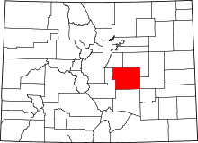 | |
| Towns | ||
| CDPs | ||
| Unincorporated communities | ||
| Former populated places | ||
| Footnotes | ‡This populated place also has portions in an adjacent county or counties | |