Ellicott, Colorado
| Ellicott, Colorado | |
|---|---|
| Census-designated place | |
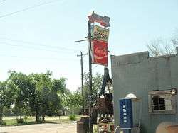 Ellicott Grocery | |
 Location of Ellicott in El Paso County, Colorado. | |
 Ellicott Location within the state of Colorado | |
| Coordinates: 38°50′18″N 104°23′13″W / 38.83833°N 104.38694°WCoordinates: 38°50′18″N 104°23′13″W / 38.83833°N 104.38694°W | |
| Country | United States |
| State | Colorado |
| Counties | El Paso |
| Area | |
| • Total | 10.9 sq mi (28.2 km2) |
| • Land | 10.9 sq mi (28.2 km2) |
| • Water | 0 sq mi (0 km2) |
| Elevation[1] | 6,020 ft (1,830 m) |
| Population (2010) | |
| • Total | 1,131 |
| • Density | 100/sq mi (40/km2) |
| Time zone | UTC-7 (MST) |
| • Summer (DST) | UTC-6 (MDT) |
| ZIP code[2] | 80808 (Calhan) |
| Area code(s) | 719 |
| FIPS code | 08-24235 |
Ellicott is a census-designated place located in El Paso County, Colorado. The population as of the 2010 Census was 1,131.[3] The U.S. Post Office at Calhan (ZIP Code 80808) now serves the Ellicott postal address.[2]
Students are served by the Ellicott School District 22.
Geography
Ellicott is located at 38°50′18″N 104°23′13″W / 38.83833°N 104.38694°W, at the intersection of State Highway 94 and the Ellicott Highway. The town is approximately 24 miles away from Colorado Springs.
Demographics
| Historical population | |||
|---|---|---|---|
| Census | Pop. | %± | |
| U.S. Decennial Census[4] | |||
See also
References
- ↑ "Geographic Names Information System Feature Detail Report". USGS. Retrieved 2007-08-15.
- 1 2 "ZIP Code Lookup". United States Postal Service. December 31, 2008. Archived from the original (JavaScript/HTML) on January 1, 2008. Retrieved December 31, 2008.
- ↑ Colorado Trend Report 2: State and Complete Places (Sub-state 2010 Census Data). Missouri Census Data Center. Accessed 2011-03-08.
- ↑ "Census of Population and Housing". Census.gov. Retrieved June 4, 2016.
Municipalities and communities of El Paso County, Colorado, United States | ||
|---|---|---|
| Cities | 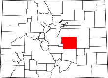 | |
| Towns | ||
| CDPs | ||
| Unincorporated communities | ||
| Former populated places | ||
| Footnotes | ‡This populated place also has portions in an adjacent county or counties | |
This article is issued from
Wikipedia.
The text is licensed under Creative Commons - Attribution - Sharealike.
Additional terms may apply for the media files.