Whoopflarea, Kentucky
| Whoopflarea | |
|---|---|
| Unincorporated community | |
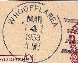 Postmark from Whoopflarea, Kentucky | |
 Whoopflarea Location within the state of Kentucky  Whoopflarea Whoopflarea (the US) | |
| Coordinates: 37°17′52″N 83°34′5″W / 37.29778°N 83.56806°WCoordinates: 37°17′52″N 83°34′5″W / 37.29778°N 83.56806°W | |
| Country | United States |
| State | Kentucky |
| County | Owsley |
| Elevation | 971 ft (296 m) |
| Time zone | UTC-5 (Eastern (EST)) |
| • Summer (DST) | UTC-4 (EDT) |
| GNIS feature ID | 516350[1] |
Whoopflarea is an unincorporated community located in Owsley County, Kentucky, United States. Its post office closed in April 1954.[2] Whoopflarea has been noted for its unusual place name.[3]
The town name has several proposed origins. The most accepted is the whoop of owls made in the remote area. Other origins include lost persons in the area and the resulting search. They literally whooped for Larry or Laura.[4]
References
- ↑ U.S. Geological Survey Geographic Names Information System: Whoopflarea, Kentucky
- ↑ http://about.usps.com/who-we-are/postmasterfinder/welcome.htm
- ↑ Strecker, Zoe; Finch, Jackie Sheckler (1 July 2009). Kentucky Off the Beaten Path. Rowman & Littlefield. p. 11. ISBN 978-0-7627-5790-9.
- ↑ Rennick, Charles (1984). Kentucky Place Names. Lexington, KY: University Press of Kentucky. p. 318.
Municipalities and communities of Owsley County, Kentucky, United States | ||
|---|---|---|
| City |  | |
| Unincorporated communities |
| |
This article is issued from
Wikipedia.
The text is licensed under Creative Commons - Attribution - Sharealike.
Additional terms may apply for the media files.