Lerose, Kentucky
| Lerose | |
|---|---|
| Unincorporated community | |
 Lerose Location within the state of Kentucky  Lerose Lerose (the US) | |
| Coordinates: 37°28′56″N 83°36′56″W / 37.48222°N 83.61556°WCoordinates: 37°28′56″N 83°36′56″W / 37.48222°N 83.61556°W | |
| Country | United States |
| State | Kentucky |
| County | Owsley |
| Elevation | 741 ft (226 m) |
| Time zone | UTC-6 (Central (CST)) |
| • Summer (DST) | UTC-5 (CST) |
| ZIP codes | 41344 |
| GNIS feature ID | 513339[1] |
Lerose[2] is a small settlement in Owsley County, Kentucky, United States,[3] in the "Kentucky Highlands" region.[4] It is 370 miles from the U.S. capital of Washington, D.C. Nearby places include the county seat of Booneville, Chestnut Gap, and Tallega. It has a cemetery[5] and several hollows.[6] The Lerose community was named after Lleaner Rose, who ran a local store. He was known by the locals as Lee Rose, thus giving the community its current name. "Lee" later had a grandson, Chester Clay Rose, who was killed in the attack on Pearl Harbor on December 7, 1941. His body is entombed in the remains of the USS Arizona.[7]
References
Municipalities and communities of Owsley County, Kentucky, United States | ||
|---|---|---|
| City | 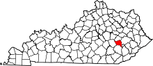 | |
| Unincorporated communities |
| |
This article is issued from
Wikipedia.
The text is licensed under Creative Commons - Attribution - Sharealike.
Additional terms may apply for the media files.