Whitford station
| SEPTA Regional Rail station | |||||||||||||||||||||
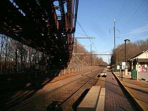 Whitford station in January 2013 | |||||||||||||||||||||
| Location | 1597 South Whitford Road and Spackmans Lane, Exton, PA 19341 USA | ||||||||||||||||||||
| Owned by | Amtrak[1] | ||||||||||||||||||||
| Operated by | SEPTA | ||||||||||||||||||||
| Line(s) |
Keystone Corridor (Main Line) | ||||||||||||||||||||
| Platforms | 2 side platforms | ||||||||||||||||||||
| Tracks | 3 | ||||||||||||||||||||
| Construction | |||||||||||||||||||||
| Parking | 229 spaces (daily) | ||||||||||||||||||||
| Bicycle facilities | 2 racks (4 spaces) | ||||||||||||||||||||
| Other information | |||||||||||||||||||||
| Fare zone | 4 | ||||||||||||||||||||
| History | |||||||||||||||||||||
| Opened | 1880 | ||||||||||||||||||||
| Electrified | 1915 | ||||||||||||||||||||
| Traffic | |||||||||||||||||||||
| Passengers (2011) | 323[2] (weekday boardings) | ||||||||||||||||||||
| Services | |||||||||||||||||||||
| |||||||||||||||||||||
| |||||||||||||||||||||
|
Whitford Railroad Station | |||||||||||||||||||||
  | |||||||||||||||||||||
| Location |
405 South Whitford Road Exton, Pennsylvania | ||||||||||||||||||||
| Coordinates | 40°00′53″N 75°38′17″W / 40.0147°N 75.6381°WCoordinates: 40°00′53″N 75°38′17″W / 40.0147°N 75.6381°W | ||||||||||||||||||||
| Built | 1880 | ||||||||||||||||||||
| Architectural style | Clapboard | ||||||||||||||||||||
| NRHP reference # | 84003324 | ||||||||||||||||||||
| Added to NRHP | 1984[3] | ||||||||||||||||||||
Whitford station is a commuter rail and former intercity passenger rail station located in the western suburbs of Philadelphia at South Whitford Road and Spackman Lane, Exton, Pennsylvania. It is served by most SEPTA Paoli/Thorndale Line trains and until 1998 some of Amtrak's Keystone Service trains.
Whitford Flyover
Whitford station is best known for the abandoned railway bridge that sits directly above the station site. The current station sits along the once-busy former Pennsylvania Railroad (PRR) four-track Main Line, which, in its prime, hosted a constant flow of commuter and long distance trains. To circumvent constant bottlenecks near Philadelphia, the PRR constructed a low-grade double-track electrified line in 1906 to host its freight traffic. This was done to bypass the steep grades and busy Philadelphia suburbs. Known as the Philadelphia and Thorndale Branch (or the "High Line"), the line ran alongside the current Paoli/Thorndale Line, crossing (or "flying") over it via a massive trestle directly above the Whitford Station. After the sharp decline in rail traffic in the 1970s, the freight line was abandoned outright by Conrail in 1989. In addition, the current passenger line was reduced from four tracks to three in the 1960s.[4]
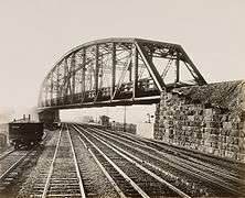
In its heyday, the PRR produced a series of calendars that included paintings of scenes throughout the extensive rail system. Artist Grif Teller captured a busy moment at Whitford in his "Main Lines—Freight and Passenger" painting from 1949, when the overhead trestle was still in use.
 Artist Grif Teller's classic Main Lines—Freight and Passenger painting captured Whitford Flyover in its prime, circa 1949. |
 The station house is just visible under the bridge in this 1904 photograph by William H. Rau. |
Current station
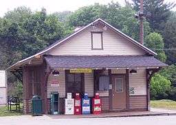
On August 2, 1984, the station house was listed on the National Register of Historic Places.[5] There is no ticket office at the station. There are 229 parking spaces at the station for daily parking, some of which sit on the abandoned freight line that crosses over the station site.
This station is 28.7 track miles from Philadelphia's Suburban Station. In 2011, the average total weekday boardings at this station was 323, and the average total weekday alightings was 315.[2]
Station layout
Whitford has two low-level side platforms. A center track is not used for passenger service.
| P Platform level | ||
| Side platform, doors will open on the right | ||
| Track 2 | ← Paoli/Thorndale Line weekdays toward Thorndale (Downingtown) ← Keystone Corridor does not stop here | |
| No service | ← No regular service → | |
| Track 1 | Keystone Corridor does not stop here → Paoli/Thorndale Line weekdays toward Suburban Station or Temple University (Malvern) → | |
| Side platform, doors will open on the right | ||
| G | Street level | Exit/entrance, parking |
References
- ↑ "Transportation Planning for the Philadelphia–Harrisburg "Keystone" Railroad Corridor" (PDF). Federal Railroad Administration. Archived from the original (PDF) on May 21, 2011. Retrieved 9 January 2013.
- 1 2 "Fiscal Year 2011 Annual Service Plan" (PDF). SEPTA. pp. 71–72. Retrieved 12 January 2013.
- ↑ Chester County Listings at the National Register of Historic Places
- ↑ Pennsylvania Railroad Stations Past and Present
- ↑ NRHP.gov
External links
| Wikimedia Commons has media related to Whitford station. |
- Historic American Engineering Record (HAER) No. PA-522, "Pennsylvania Railroad, Whitford Bridge"
- SEPTA - Whitford Station
| Topics |   | |
|---|---|---|
| Lists by county |
| |
| Lists by city | ||
| Other lists | ||
| ||