Whitehall Street
Whitehall Street is a street in the New York City borough of Manhattan, about four blocks long. The street begins at the southern end of Broadway, at the intersection with Stone Street. Whitehall Street stretches south to the southern end of FDR Drive, adjacent to the Staten Island Ferry's Whitehall Terminal, on landfill beyond the site of Peter Stuyvesant's 17th-century house.
The street is one-way southbound for three blocks from Bowling Green to Pearl Street, and one-way northbound up from the FDR Drive to Pearl Street. The southernmost block, adjacent to the ferry terminal, provides access from FDR Drive to the Battery area.
Nearby structures
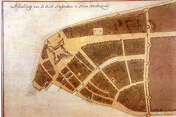
Near the foot of the street is the site of the Governor's house built by Peter Stuyvesant; when the British took over New Amsterdam from the Dutch, they christened the street and the building "Whitehall" for England's seat of government, Whitehall, London.[1] On the Castello map (1660, illustration) Whitehall, with its white roof, stands on a jutting piece of land at Manhattan's tip, facing along the waterfront strand that extends along the East River. The only extensive pleasure gardens in seventeenth-century Nieuw Amsterdam/New York are seen to extend behind it, laid out in a patterned parterre of four squares. Other grounds in the center of blocks behind houses are commons and market gardens. The mansion is long since gone, and now the name survives only as the short north-south Whitehall Street.[2]
In the 2000s the Metropolitan Transportation Authority renovated the Topps Corporation office building at 2 Broadway, to use as a new headquarters.[3] There are several other office buildings and low-density shops on that street.
_pg547_US_ARMY_BUILDING%2C_WHITEHALL%2C_PEARL_AND_WATER_STREETS.jpg)
From 1884 to the end of the Vietnam War, the Army Building, used as offices, a military recruiting center, and an Armed Forces Examination and Entrance Station (i.e., induction center), was located at 39 Whitehall Street, at the intersection of White Hall, Pearl, and Water Streets.[4][5] Nearly three million Americans were inducted at the Army building before being closed after two bombings by war resisters (in 1968 and 1969[6]).[7] The damage was superficial, however,[8] and the building has been repurposed as a glass-skinned condominium, with retail space and the alternate address: 3 New York Plaza.[9]
Transportation
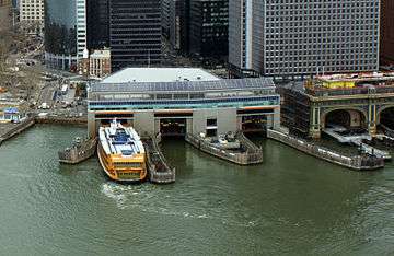
There is an active passenger ferry terminal at the southern tip of Whitehall Street: the Whitehall Terminal, which serves the Staten Island Ferry. However, its facilities in use have shifted over the decade, as have the destinations served. The original Whitehall Terminal served Brooklyn, Governors Island, Staten Island, and Jersey City, New Jersey, and it was originally served mainly by the Interborough Rapid Transit Company's elevated train lines at South Ferry station. Furthermore, the terminal once served vehicular traffic.[10] However, the subways have replaced the els, and cars now use fixed crossings such as the Brooklyn-Battery Tunnel.[11]:24 The structure was renovated in the 1950s and reopened in 1956.[12] It was destroyed by fire in 1991.[13] It was renovated in 1992–2005.[14]
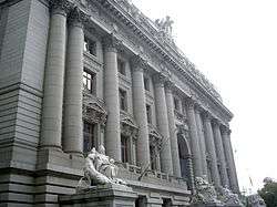
The Battery Maritime Building, housing the ferry to Governors Island, is located just east of the Whitehall Terminal. It is open to the public from April through October.[15] The terminal was renovated in 2001–2005.[16] The building is listed on the National Register of Historic Places.[17]
The Whitehall Street–South Ferry station (1, N, R, and W trains) of the New York City Subway is located on Whitehall Street.[18] Entrances are located at the northern and southern ends of the street (at Stone Street and the Staten Island Ferry terminal, respectively).[19] The Bowling Green subway station (4 and 5 trains), just steps away from the Alexander Hamilton U.S. Custom House,[19] is also on Whitehall Street.[19][18]
In popular culture
The former military induction center at 39 Whitehall Street was made famous in Arlo Guthrie's "Alice's Restaurant."[20]
References
- ↑ Moscow, Henry (1979). The Street Book: An Encyclopedia of Manhattan's Street Names and Their Origins. New York: Fordham University Press. p. 112. ISBN 0-8232-1275-0.
- ↑ Urban, Sylvanus, Jr. (January 12, 1902). "Sale of Stuyvesant Property Recalls Old Bouerie's Story". The New York Times. p. SM11. Retrieved November 9, 2008.
- ↑ Bagli, Charles V. (2000-08-09). "Brass Knuckles Over 2 Broadway; M.T.A. and Landlord Are Fighting It Out Over Rent and Renovations". The New York Times. Retrieved 2018-06-20.
- ↑ Gray, Christopher (May 7, 2009). "Look Familiar, Men? Maybe You Were There". The New York Times.
- ↑ Daly, Michael (August 1, 2004). "Where Recruits No Longer Feel Draft". New York Daily News.
- ↑ Gray, Christopher (May 7, 2009). "Look Familiar, Men? Maybe You Were There". The New York Times.
- ↑ Yarrow, Andrew L. (May 26, 1989). "Out of New York's Military Past". The New York Times. Retrieved November 9, 2008.
- ↑ Gray, Christopher (May 7, 2009). "Look Familiar, Men? Maybe You Were There". The New York Times.
- ↑ "39 Whitehall Street, New York, NY 10004". Property Shark.
- ↑ Staten Island Museum website, retrieved February 22, 2011.
- ↑ White, Norval; Willensky, Elliot & Leadon, Fran (2010), AIA Guide to New York City (5th ed.), New York: Oxford University Press, ISBN 9780195383867
- ↑ "FERRY STATION TO OPEN; $2,800,000 Whitehall Terminal Starts Operating Today". The New York Times. 1956-07-24. ISSN 0362-4331. Retrieved 2017-09-20.
- ↑ McFadden, Robert D. (1991-09-09). "BIG FIRE DESTROYS TERMINAL OF FERRY TO STATEN ISLAND". The New York Times. ISSN 0362-4331. Retrieved 2017-09-20.
- ↑ Hill, John. Guide to Contemporary New York City Architecture. New York and London: W.W. Norton & Company. p. 20. ISBN 978-0-393-73326-6.
- ↑ "Governors Island Ferry Service". New York City's Historic Battery Maritime Building. Retrieved 2018-06-22.
- ↑ New York City Landmarks Preservation Commission; Dolkart, Andrew S.; Postal, Matthew A. (2009), Postal, Matthew A., ed., Guide to New York City Landmarks (4th ed.), New York: John Wiley & Sons, ISBN 978-0-470-28963-1 , p.8-9
- ↑ National Park Service (July 9, 2010). "National Register Information System – Municipal Ferry Pier (#76001246)". National Register of Historic Places. National Park Service. Retrieved June 22, 2018.
- 1 2 "Subway Map" (PDF). Metropolitan Transportation Authority. January 18, 2018. Retrieved January 18, 2018.
- 1 2 3 "MTA Neighborhood Maps: Lower Manhattan" (PDF). mta.info. Metropolitan Transportation Authority. 2018. Retrieved October 1, 2018.
- ↑ Yarrow, Andrew L. (May 26, 1989). "Out of New York's Military Past". The New York Times. Retrieved November 9, 2008.
Coordinates: 40°42′10.16″N 74°0′46.89″W / 40.7028222°N 74.0130250°W