White Coomb
| White Coomb | |
|---|---|
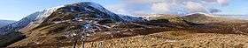 White Coomb and Loch Skeen from the east | |
| Highest point | |
| Elevation | 821 m (2,694 ft) |
| Prominence | 374 m (1,227 ft) |
| Listing | Marilyn, Corbett, Donald |
| Geography | |
| Location | Dumfries and Galloway, Scotland |
| Parent range | Southern Uplands |
| OS grid | NT163151 |
| Topo map | OS Landranger 79 |
White Coomb is a hill in the Southern Uplands of Scotland. Its summit is the highest point of a network of ridges that lie north-east of the town of Moffat in the Moffat Hills. The ridges are broad, but are defended by steep valleys. The summit marks the highest point in the registration county of Dumfries.
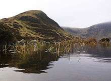
White Coomb is most easily climbed from the National Trust for Scotland car park underneath the Grey Mare's Tail waterfall, on the A708 from Moffat to Selkirk, at NT 186146. The most direct route heads directly west up a steep ridge, but a more comfortable route follows a well built footpath above the north side of the waterfall. Above the waterfall, the fast flowing Tail Burn must be crossed to avoid a long detour; although there are plenty of natural stepping stones, spate or icy conditions may make their use dangerous. From across the stream, the best route through the peat and heather follows the course of a wall leading to the summit of Upper Tarnberry (546 m). From there, the east ridge, which is steep and craggy in places, leads to the broad summit.
An alternative ascent, described by the Daily Telegraph as one of "Britain's finest half-day and day walks", follows the Tail Burn to the outlet of Loch Skeen before ascending the ridge to Mid Craig, and passing Donald's Cleuch Head to reach the summit. The descent suggested is via Rough Craig and south to join the road and walk back to the start point.[1]
Subsidiary summits
The Database of British and Irish hills[2] lists 18 subsidiary summits of White Coomb.
| Summit | Height (m) | Drop (m) | Grid ref | Notes[3] |
|---|---|---|---|---|
| White Coomb | 821 | 374 | NT163150 | Ma,C,D,CoH, cairn |
| Cape Law | 722 | 93 | NT131150 | D,GTC,sHu, fence corner |
| Carlavin Hill | 736 | 23 | NT142188 | DT,sGT, |
| Carrifran Gans | 757 | 42 | NT159138 | GTC,DT, no feature |
| Din Law | 667 | 53 | NT124157 | GTC,DT, small cairn |
| Ellers Cleuch Rig | 610 | 7 | NT126166 | xDT, no feature |
| Erie Hill | 690 | 92 | NT124187 | D,GTC,sHu, cairn |
| Firthhope Rig | 800 | 26 | NT153153 | DT,sCT, no feature |
| Firthybrig Head | 764 | 7 | NT158171 | xDT, wall junction |
| Garelet Dod | 698 | 126 | NT126172 | Hu,D,GTC, no feature |
| Garelet Hill | 680 | 24 | NT124201 | DT,sGT, trig point: OS measurement |
| Great Hill | 774 | 28 | NT145163 | DT,sCT, |
| Laird's Cleuch Rig [Lairds Cleuch Rig] | 684 | 50 | NT125196 | GTC,DT, |
| Lochcraig Head | 801 | 108 | NT167176 | Hu,CTC,D, cairn |
| Mid Craig | 729 | 21 | NT164164 | sGT, |
| Molls Cleuch Dod | 785 | 39 | NT151179 | CTC,D, cairn |
| Nickies Knowe | 761 | 29 | NT164191 | DT,sGT, no feature |
| Saddle Yoke | 735 | 30 | NT144123 | GTC,DT, small cairn |
| Under Saddle Yoke | 745 | 128 | NT142126 | Hu,D,GTC, no feature |
References
- The Corbetts and Other Scottish Hills, (SMC Guide) ISBN 0-907521-29-0
- ↑ "Britain's finest half-day and day walks: 18. Loch Skeen and White Coomb". Daily Telegraph. London. 25 September 2009. Retrieved 4 August 2012.
- ↑ "Database of British and Irish Hills". Retrieved 4 August 2012.
- ↑ Abbreviations used: C = Corbett, CoH = County Top - Historic, CTC = Corbett Top of Corbett, D = Donald, Ma = Marilyn, GTC = Graham Top of Corbett, Hu = HuMP, sGT= sub-Graham Top, sHu = sub-HuMP, xGT = deleted Graham Top