Weston and Gauley Bridge Turnpike
|
Weston and Gauley Bridge Turnpike | |
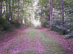 Weston and Gauley Bridge Turnpike, Bulltown WV, August 2006 | |
  | |
| Location | Section between Stonewall Jackson Lake and Burnsville Lake, Burnsville, West Virginia |
|---|---|
| Coordinates | 38°49′39″N 80°32′7″W / 38.82750°N 80.53528°WCoordinates: 38°49′39″N 80°32′7″W / 38.82750°N 80.53528°W |
| Area | 27 acres (11 ha) |
| Built | 1861 |
| NRHP reference # | [1] |
| Added to NRHP | January 28, 1999 |
Weston and Gauley Bridge Turnpike is a historic turnpike located at Burnsville, Braxton County, West Virginia. It is a 10 mile long section of trail, approximately 20 feet in width, with an unpaved surface. It is administered by the Army Corps of Engineers. The route was built starting in 1847 to provide access to Sutton for transport of product to grist mills and sawmills, and provided access to the Bulltown sawmills. During the American Civil War, the turnpike was used in 1861 by Union troops to move to take control of western Virginia. It was also critical in the movement of troops during the Battle of Bulltown on October 13, 1863.[2]
It was listed on the National Register of Historic Places in 1995.[1]
References
- 1 2 National Park Service (2009-03-13). "National Register Information System". National Register of Historic Places. National Park Service.
- ↑ Paige Cruz (February 1998). "National Register of Historic Places Inventory Nomination Form: Weston and Gauley Bridge Turnpike" (PDF). State of West Virginia, West Virginia Division of Culture and History, Historic Preservation. Retrieved 2011-06-02.
| Topics |  | |
|---|---|---|
| Lists by county |
| |
| Other lists | ||
| ||
This article is issued from
Wikipedia.
The text is licensed under Creative Commons - Attribution - Sharealike.
Additional terms may apply for the media files.