Westcott, Surrey
| Westcott | |
|---|---|
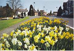 Village green area with flowers | |
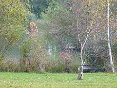 A dammed part of the Pipp Brook forms the Lake at Westcott | |
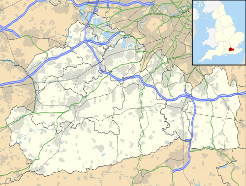 Westcott Westcott shown within Surrey | |
| Population | 2,251 (2011 census)[1] |
| OS grid reference | TQ1448 |
| Civil parish |
|
| District | |
| Shire county | |
| Region | |
| Country | England |
| Sovereign state | United Kingdom |
| Post town | Dorking |
| Postcode district | RH4 |
| Dialling code | 01306 |
| Police | Surrey |
| Fire | Surrey |
| Ambulance | South East Coast |
| EU Parliament | South East England |
| UK Parliament | |
Westcott is a semi-rural English village and former civil parish 1.5 miles (2.4 km) west of the centre of Dorking on the A25 between the North Downs and Greensand Ridge, making it one of the 'Vale of Holmesdale' villages (greatly in Westcott an AONB) and is in Surrey in the direction of Guildford. It is served by a local bus service and is 1 mile (1.6 km) from Dorking West railway station on the North Downs Line.
Topography
The village is drained solely by the midsection of the Pipp Brook from Wotton Common and sources in the parish (rising at its furthest source 3 miles (4.8 km) south at Leith Hill), which then flows by the village centre in its northern farmland flowing into Dorking and discharging at the lowest part of Dorking's former other chapelry in Pixham. As such the village was rooted on its road, the A25 and mill and rests in a valley at the foot of the steep slopes of Ranmore and the North Downs to the north and Greensand Ridge to the south. Some of the village is in the Surrey Hills AONB and its single through-road in two directions is on the annual London-Surrey cycle classic route.
In Squire's Wood, south of Westcott, is Mag's Well, one of the sources of Pipp Brook. It was formerly of some repute as a medicinal spring, and is strongly impregnated with iron. A building, ruined, existed over it, and in the Victorian period children still bathed in it.[2]
There is a thatched dovecot on the village green. The weather vane on top of the dovecot has had the N replaced by a T such that it now shows the letters WEST.
History
Westcott or Westcote lay in the Wotton Hundred. It along with superseded Milton was the upper borough, turned into a chapelry of Dorking also in the Victorian period. The lower hamlet being Pixham As such, it contributed significantly to the wealth and trade of Dorking, including in the wool and meat from sheep farming on the North Downs within the parish bounds.[2]
Bury Hill here was recorded in the 15th century. It became a manor, formed from waste (infertile land) of the manor of Milton, Dorking. James Walter was buying the land in 1753 and he built the house then and planted the grounds. He died 1780, when the 3rd Viscount Grimston, his daughter's husband, succeeded him here. In 1812 his son and heir, about to be created Earl of Verulam, sold it to a wealthy Scottish individual, Robert Barclay and it descended to his Barclay heir in the Edwardian period when The Nower was "a [neighbouring] favourite [hill] walk for Dorking people" and he was the ancestor of comedy executive/producer Humphrey Barclay.[3]
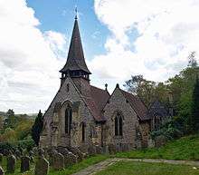
Many pre-1800 listed building homes including some that are thatched are in the lanes leading off the A25, including Leslie Howard's (actor 1893–1943) Stowe Maries (built in the 1550s) in Balchins Lane. Milton Street and Westcott Street lead to several more old buildings.[4] The Church of the Holy Trinity is Grade II* as it was commissioned to be designed 1851, by Sir George Gilbert Scott made of knapped flint with ashlar quoins/dressings. Its spire has a clock, weather vane and bells within its[5] 14th-century style. It is of stone, with a small western turret. Charles Barclay of Bury Hill gave equivalent to £100,482 in 2016 for it to be built, and Lady Mary Leslie the same as endowment. The clock was put up to commemorate the Jubilee of 1887. The parsonage house was built at the sole expense of Barclay and the secular Westcote Schools were built by subscription in 1854; and an infant school by subscription in 1882.[3]
It was the second nearest village, with some trade, to John Evelyn's Wotton House and Estate, well known by the diarist, garden landscaper and society favourite in the mid to late 17th century; in 1694 Evelyn moved into his completed house.
Economy and amenities
The average distance travelled to work is 17 kilometres (11 mi).[6]
Of the original three public houses The Prince of Wales remains. The Crown finally closed in September 2011. Bay Leaf,[7] a popular Indian restaurant is a feature of the village, an ingenious reinvention of the rather old public house, The Cricketers.
It has an art gallery, a number of small stores, a bicycle shop and one general store. A second general store with integrated Post Office closed in December 2016. The village is busy with cyclists every weekend as the area offers some of the best mountain biking in Southern England.
Westcott's village school celebrated its 150th anniversary in 2004. In 2010 it was merged with the nearby Abinger Common to create a two-campus school known as the Surrey Hills Church of England Primary School.
In 2009 a skate ramp and football goals were installed in the village park.
Demography and housing
| Ward | Detached | Semi-detached | Terraced | Flats and apartments | Caravans/temporary/mobile homes/houseboats | Shared between households[1] |
|---|---|---|---|---|---|---|
| Westcott | 339 | 309 | 126 | 143 | 1 | 0 |
The average level of accommodation in the region composed of detached houses was 28%, the average that was apartments was 22.6%.
| Ward | Population | Households | % Owned outright | % Owned with a loan | hectares[1] |
|---|---|---|---|---|---|
| Westcott | 2,251 | 918 | 39 | 34 | 978 |
The proportion of households who owned their home outright compares to the regional average of 35.1%. The proportion who owned their home with a loan compares to the regional average of 32.5%. The remaining % is made up of rented dwellings (plus a negligible % of households living rent-free).
See also
![]()
![]()
Gallery
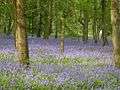 Bluebells in woods in the south of Westcott
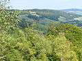 Pickett's Hole is in the north of Westcott, an escarpment with deciduous woods which adjoins Ranmore Common
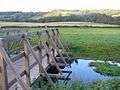 Pipp Brook footbridge in fields to the immediate north of the village centre
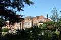 Milton Court is close to the southern woods
References
- 1 2 3 Key Statistics; Quick Statistics: Population Density United Kingdom Census 2011 Office for National Statistics Retrieved 20 December 2013
- 1 2 H.E. Malden, ed. (1911). "The hundred of Wotton: Introduction and map". A History of the County of Surrey: Volume 3. Institute of Historical Research. Retrieved 28 December 2013.
- 1 2 H.E. Malden, ed. (1911). "Parishes: Dorking". A History of the County of Surrey: Volume 3. Institute of Historical Research. Retrieved 28 December 2013.
- ↑ English Heritage search for Westcott
- ↑ Historic England. "Details from listed building database (1227892)". National Heritage List for England. Retrieved 5 June 2012. Church of The Holy Trinity
- ↑ 2001 census table
- ↑ Bay Leaf Dorking
External links
- Obsessive Compulsive Hoarder Channel 4 programme that features Westcott, reviewed here
- Court victory for eccentric homeowner Daily Mail story about Westcott resident
Neighbouring areas of Surrey | |
|---|---|
|
|  | ||||||||||||||||
|---|---|---|---|---|---|---|---|---|---|---|---|---|---|---|---|---|---|---|
| Parks | ||||||||||||||||||
| Places of worship | ||||||||||||||||||
| Education | ||||||||||||||||||
| Transport |
| |||||||||||||||||
Buildings and structures | ||||||||||||||||||
| Sport |
| |||||||||||||||||
Places listed are articles notable as settlements, arranged by post town The two principal towns are emboldened | ||||||||||||||||||