West Point, Kansas
| West Point, Kansas | |
|---|---|
| Coordinates: 38°31′25″N 99°26′16″W / 38.52361°N 99.43778°WCoordinates: 38°31′25″N 99°26′16″W / 38.52361°N 99.43778°W | |
| Country | United States |
| State | Kansas |
| County | Rush |
| Elevation | 2,100 ft (640 m) |
| Time zone | UTC-6 (Central (CST)) |
| • Summer (DST) | UTC-5 (CDT) |
| GNIS feature ID | 482546[1] |


West Point was a small settlement in Rush County, Kansas, United States.
History
West Point was issued a post office in 1878. The post office was discontinued in 1894.[2]
References
- ↑ "US Board on Geographic Names". United States Geological Survey. 1984-07-01. Retrieved 2017-12-30.
- ↑ "Kansas Post Offices, 1828-1961". Kansas Historical Society. Retrieved 2017-12-30.
Municipalities and communities of Rush County, Kansas, United States | ||
|---|---|---|
| Cities | 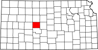 | |
| Unincorporated communities | ||
| Ghost towns | ||
This article is issued from
Wikipedia.
The text is licensed under Creative Commons - Attribution - Sharealike.
Additional terms may apply for the media files.