Hargrave, Kansas
| Hargrave, Kansas | |
|---|---|
| Unincorporated community | |
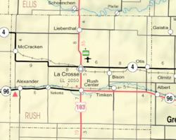 KDOT map of Rush County (legend) | |
| Coordinates: 38°33′23″N 99°26′42″W / 38.55639°N 99.44500°WCoordinates: 38°33′23″N 99°26′42″W / 38.55639°N 99.44500°W[1] | |
| Country | United States |
| State | Kansas |
| County | Rush |
| Elevation[1] | 2,178 ft (664 m) |
| Area code | 785 |
| FIPS code | 20-30025 [1] |
| GNIS ID | 484735 [1] |


Hargrave is an unincorporated community in Rush County, Kansas, Kansas, United States.[1]
History
Hargrave had a post office between the 1890s and 1950.[2]
Geography
Hargrave is located approximately 7 miles west of La Crosse on the north side of K-4 highway next to the Kansas and Oklahoma Railroad.
Further reading
References
- 1 2 3 4 5 Geographic Names Information System (GNIS) details for Hargrave, Kansas; United States Geological Survey (USGS); October 13, 1978.
- ↑ "Kansas Post Offices, 1828-1961". Kansas Historical Society. Archived from the original on October 9, 2013. Retrieved 22 June 2014.
External links
- Hargrave - a Dead Town in Rush County, Kansas Agland
Municipalities and communities of Rush County, Kansas, United States | ||
|---|---|---|
| Cities | 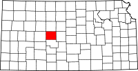 | |
| Unincorporated communities | ||
| Ghost towns | ||
This article is issued from
Wikipedia.
The text is licensed under Creative Commons - Attribution - Sharealike.
Additional terms may apply for the media files.