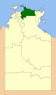
West Arnhem Region
| West Arnhem Regional Council Northern Territory | |||||||||||||||
|---|---|---|---|---|---|---|---|---|---|---|---|---|---|---|---|
 | |||||||||||||||
| Population | 6,188 (2016 census)[1] | ||||||||||||||
| • Density | 0.124512/km2 (0.322485/sq mi) | ||||||||||||||
| Established | 2008 | ||||||||||||||
| Area | 49,698 km2 (19,188.5 sq mi) | ||||||||||||||
| Mayor | Matthew Ryan | ||||||||||||||
| Council seat | Jabiru | ||||||||||||||
| Region | Arnhem Land | ||||||||||||||
| Territory electorate(s) | Arafura | ||||||||||||||
| Federal Division(s) | Lingiari | ||||||||||||||
 | |||||||||||||||
| Website | West Arnhem Regional Council | ||||||||||||||
| |||||||||||||||
The West Arnhem Regional Council is a local government area of the Northern Territory, Australia. The region covers an area of 49,698.26 km² and had a population of approximately 6,200 at the 2016 Census.
History
In October 2006 the Northern Territory Government announced the reform of local government areas. The intention of the reform was to improve and expand the delivery of services to towns and communities across the Northern Territory by establishing eleven new shires. The West Arnhem Shire was created on 1 July 2008.
Elections of Shire Councillors were held on 25 October 2008. The current Mayor of the West Arnhem Shire is Matthew Ryan (2017).
On 1 January 2014, the Shire became the West Arnhem Region.
The Region formerly consisted of unincorporated land, plus small areas under the control of Community Government Councils or incorporated communities:
- Town of Jabiru
- Maningrida Community
- Gunbalanya Community
- Minjilang Community
- Warruwi Community
Wards
West Arnhem Regional Council is divided into four wards with three councillors each:
- Gunbalanya (3)
- Kakadu (3)
- Maningrida (3)
- Barrah (3)
Towns
References
- ↑ Australian Bureau of Statistics (27 June 2017). "West Arnhem (R)". 2016 Census QuickStats. Retrieved 10 April 2018.

External links
Coordinates: 12°40′01″S 132°49′59″E / 12.66694°S 132.83306°E