Weedon railway station
| Weedon | |
|---|---|
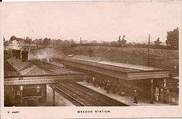 Weedon station in the 1900s | |
| Location | |
| Place | Weedon Bec |
| Area | Daventry |
| Operations | |
| Original company | London and North Western Railway |
| Pre-grouping | London and North Western Railway |
| Post-grouping | London, Midland and Scottish Railway |
| Platforms | 3 |
| History | |
| 1888 | Opened |
| 15 September 1958 | Closed |
| Disused railway stations in the United Kingdom | |
|
Closed railway stations in Britain A B C D–F G H–J K–L M–O P–R S T–V W–Z | |
|
| |
Weedon railway station was a railway station situated to the north of and serving the village of Weedon in Northamptonshire, England. It was situated on the West Coast Main Line, and was also the starting point of the Weedon to Leamington Spa branch line, one platform of the station was dedicated for terminating branch line trains. The station also housed a busy goods depot which was attacked by German aircraft during the Second World War.[1]
The station closed for passengers on 15 September 1958 (concurrently with the branch to Leamington Spa) and was demolished soon after. The fast lines of the West Coast Main Line pass through the site (the slow lines divert via Long Buckby and Northampton).
There has been periodic talk of reopening a station at Weedon, but as yet no firm plans have been submitted.[2]
Accidents and incidents
South of the station, two serious derailments in 1915 and 1951 occurred, killing 10 and 15 people respectively.
Routes
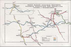
| Preceding station | Disused railways | Following station | ||
|---|---|---|---|---|
| Welton Line open, station closed |
London and Birmingham Railway | Blisworth Line open, station closed | ||
| Daventry Line and station closed |
London and North Western Railway Weedon to Leamington Spa line |
Terminus | ||
References
| Wikimedia Commons has media related to Weedon railway station. |
- ↑ http://www.northamptonshire-history.org.uk/node/215
- ↑ "New train station could come to Weedon". daventryexpress.co.uk. Daventry Express. 20 May 2012. Retrieved 19 November 2014.
- Butt, R. V. J. (1995). The Directory of Railway Stations: details every public and private passenger station, halt, platform and stopping place, past and present (1st ed.). Sparkford: Patrick Stephens Ltd. ISBN 978-1-85260-508-7. OCLC 60251199.
- Jowett, Alan (2000). Jowett's Nationalised Railway Atlas (1st ed.). Penryn, Cornwall: Atlantic Transport Publishers. ISBN 978-0-906899-99-1. OCLC 228266687.