Wayne Township, Buchanan County, Missouri
| Wayne Township | |
|---|---|
| Township | |
 | |
| Coordinates: 39°40′30″N 094°56′25″W / 39.67500°N 94.94028°WCoordinates: 39°40′30″N 094°56′25″W / 39.67500°N 94.94028°W | |
| Country | United States |
| State | Missouri |
| County | Buchanan |
| Area | |
| • Total | 33.96 sq mi (87.94 km2) |
| • Land | 33.3 sq mi (86.26 km2) |
| • Water | 0.65 sq mi (1.69 km2) 1.92% |
| Elevation[1] | 804 ft (245 m) |
| Population (2000) | |
| • Total | 705 |
| • Density | 21.2/sq mi (8.2/km2) |
| FIPS code | 29-77974[2] |
| GNIS feature ID | 0766347 |
Wayne Township is one of twelve townships in Buchanan County, Missouri, USA. As of the 2000 census, its population was 705.
Wayne Township was established in 1842.[3]
Geography
Wayne Township covers an area of 33.96 square miles (88.0 km2) and contains no incorporated settlements. It contains two cemeteries: Bethel and Kerlin.
Horseshoe Lake, Muskrat Lake, New Mud Lake and Old Mud Lake are within this township. The stream of Contrary Creek runs through this township.
References
- ↑ "US Board on Geographic Names". United States Geological Survey. 2007-10-25. Retrieved 2008-01-31.
- ↑ "American FactFinder". United States Census Bureau. Retrieved 2008-01-31.
- ↑ "Buchanan County Place Names, 1928–1945 (archived)". The State Historical Society of Missouri. Retrieved 4 September 2016.
External links
Municipalities and communities of Buchanan County, Missouri, United States | ||
|---|---|---|
| Cities | 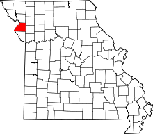 | |
| Villages | ||
| Townships | ||
| Unincorporated communities | ||
| Footnotes | ‡This populated place also has portions in an adjacent county or counties | |
This article is issued from
Wikipedia.
The text is licensed under Creative Commons - Attribution - Sharealike.
Additional terms may apply for the media files.