Watsons Bay ferry wharf
Watsons Bay | |||||||||||||
|---|---|---|---|---|---|---|---|---|---|---|---|---|---|
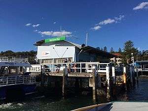 Watsons Bay ferry wharf in April 2017 | |||||||||||||
| Location |
Military Road, Watsons Bay New South Wales Australia | ||||||||||||
| Coordinates | 33°50′36″S 151°16′52″E / 33.84344°S 151.28104°ECoordinates: 33°50′36″S 151°16′52″E / 33.84344°S 151.28104°E | ||||||||||||
| Owned by | Roads & Maritime Services | ||||||||||||
| Operated by | Harbour City Ferries | ||||||||||||
| Platforms | 1 wharf (2 berths) | ||||||||||||
| Connections |
| ||||||||||||
| Other information | |||||||||||||
| Status | Unstaffed | ||||||||||||
| |||||||||||||
Watsons Bay ferry wharf is located on the southern side of Sydney Harbour serving the Sydney suburb of Watsons Bay.
Services
Watsons Bay wharf is served by Sydney Ferries Cross Harbour services operated by SuperCat class ferries.[1]
Watsons Bay wharf is also served by Captain Cook Cruises peak hour commuter services to Circular Quay.[2] At other times the Captain Cook Cruises Hop On/Hop Off Sydney Harbour ferry service operates via Watsons Bay wharf.[3]
Sydney Harbour Eco Hopper operates Sydney Harbour tourist services via Watsons Bay.[4]
| Platform | Line | Stopping pattern | Notes |
| 1 | Services to Pyrmont Bay | ||
|---|---|---|---|
| Captain Cook Cruises Watsons Bay Rocket | peak hour only[2] | ||
| Captain Cook Cruises Harbour Explorer |
| [3] | |
| Sydney Harbour Eco Hopper |
| [4] |
Interchanges
State Transit operate three routes from the other side of Robertson Park:
- 324: to Circular Quay via Vaucluse[5]
- 325: to Circular Quay via Nielsen Park[6]
- 380: to Bondi Junction via Bondi Beach[7]
References
- ↑ F4 TimetableTransport for NSW
- 1 2 "Watsons Bay Rocket timetable" (PDF). Captain Cook Cruises. 7 April 2015.
- 1 2 "Harbour Explorer timetable" (PDF). Captain Cook Cruises. 14 May 2015.
- 1 2 "Eco Hopper Timetable". Bass & Flinders. 5 April 2015.
- ↑ "State Transit route 324". Transport for NSW.
- ↑ "State Transit route 325". Transport for NSW.
- ↑ "State Transit route 380". Transport for NSW.
External links
| Wikimedia Commons has media related to Watsons Bay ferry wharf, Sydney. |
- Watsons Bay Wharf at Transport for New South Wales (Archived 29 November 2017)
This article is issued from
Wikipedia.
The text is licensed under Creative Commons - Attribution - Sharealike.
Additional terms may apply for the media files.