Waskaganish Airport
| Waskaganish Airport | |||||||||||
|---|---|---|---|---|---|---|---|---|---|---|---|
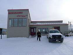 The old airport's main building in front of the airstrip, January 2011 | |||||||||||
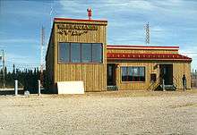 The same building, July 1987 | |||||||||||
| Summary | |||||||||||
| Airport type | Public | ||||||||||
| Operator | Transport Canada | ||||||||||
| Location | Waskaganish, Quebec | ||||||||||
| Time zone | EST (UTC−05:00) | ||||||||||
| • Summer (DST) | EDT (UTC−04:00) | ||||||||||
| Elevation AMSL | 79 ft / 24 m | ||||||||||
| Coordinates | 51°28′24″N 078°45′30″W / 51.47333°N 78.75833°WCoordinates: 51°28′24″N 078°45′30″W / 51.47333°N 78.75833°W | ||||||||||
| Map | |||||||||||
 CYKQ Location in Quebec | |||||||||||
| Runways | |||||||||||
| |||||||||||
| Statistics (2010) | |||||||||||
| |||||||||||
Waskaganish Airport, (IATA: YKQ, ICAO: CYKQ), is located near the town of Waskaganish, Quebec, Canada.
Airlines and destinations
| Airlines | Destinations |
|---|---|
| Air Creebec | Chibougamau, Chisasibi, Eastmain, Kuujjuarapik, Montreal-Trudeau, Moosonee, Nemaska, Val-d'Or, Wemindji [3] |
References
- ↑ Canada Flight Supplement. Effective 0901Z 19 July 2018 to 0901Z 13 September 2018.
- ↑ Total aircraft movements by class of operation
- ↑ Air Creebec Archived 2008-01-22 at the Wayback Machine.
External links
- Past three hours METARs, SPECI and current TAFs for Waskaganish Airport from Nav Canada as available.
| By name | |
|---|---|
| By location indicator | |
| By province/territory | |
| By area | |
| National Airports System | |
| Related | |
| |
This article is issued from
Wikipedia.
The text is licensed under Creative Commons - Attribution - Sharealike.
Additional terms may apply for the media files.