Washita, Oklahoma
| Washita, Oklahoma | |
|---|---|
| Unincorporated community | |
 Washita Location within the state of Oklahoma  Washita Washita (the US) | |
| Coordinates: 35°6′10″N 98°20′27″W / 35.10278°N 98.34083°WCoordinates: 35°6′10″N 98°20′27″W / 35.10278°N 98.34083°W | |
| Country | United States |
| State | Oklahoma |
| County | Caddo |
| Time zone | UTC-6 (Central (CST)) |
| • Summer (DST) | UTC-5 (CDT) |
| ZIP codes | 73094 |
| GNIS feature ID | 1099413 |
Washita is a rural community in Caddo County, Oklahoma.[1] It is located west of Anadarko on a bend in the Washita River. The post office opened April 16, 1910.[2]
A municipal electrical power generation plant for Anadarko is located in Washita.
References
- ↑ U.S. Geological Survey Geographic Names Information System: Washita, Oklahoma
- ↑ Shirk, George H. Oklahoma Place Names. Norman: University of Oklahoma Press, 1987, p.250. ISBN 0-8061-2028-2
Municipalities and communities of Caddo County, Oklahoma, United States | ||
|---|---|---|
| City | 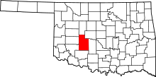 | |
| Towns | ||
| Unincorporated communities | ||
| Footnotes | ‡This populated place also has portions in an adjacent county or counties. | |
This article is issued from
Wikipedia.
The text is licensed under Creative Commons - Attribution - Sharealike.
Additional terms may apply for the media files.