Washington Township, Pike County, Indiana
| Washington Township Pike County | |
|---|---|
| Township | |
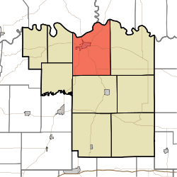 Location in Pike County | |
| Coordinates: 38°28′36″N 87°15′23″W / 38.47667°N 87.25639°WCoordinates: 38°28′36″N 87°15′23″W / 38.47667°N 87.25639°W | |
| Country |
|
| State |
|
| County | Pike |
| Government | |
| • Type | Indiana township |
| Area | |
| • Total | 45.12 sq mi (116.9 km2) |
| • Land | 44.09 sq mi (114.2 km2) |
| • Water | 1.03 sq mi (2.7 km2) 2.28% |
| Elevation | 472 ft (144 m) |
| Population (2010) | |
| • Total | 4,460 |
| • Density | 101.2/sq mi (39.1/km2) |
| ZIP codes | 47567, 47598 |
| GNIS feature ID | 454013 |
Washington Township is one of nine townships in Pike County, Indiana, United States. As of the 2010 census, its population was 4,460 and it contained 2,000 housing units.[1]
Geography
According to the 2010 census, the township has a total area of 45.12 square miles (116.9 km2), of which 44.09 square miles (114.2 km2) (or 97.72%) is land and 1.03 square miles (2.7 km2) (or 2.28%) is water.[1] The White River defines the township's northern border, as well as the northern border of Pike County.
Cities, towns, villages
Unincorporated towns
- Alford at 38°29′29″N 87°14′34″W / 38.491438°N 87.24279°W
- Arda at 38°31′02″N 87°15′02″W / 38.517271°N 87.250568°W
- Ashby Yards at 38°28′28″N 87°17′05″W / 38.474493°N 87.284735°W
- Rogers at 38°32′18″N 87°13′26″W / 38.538383°N 87.223901°W
- West Petersburg at 38°29′15″N 87°17′21″W / 38.487549°N 87.289180°W
- Willisville at 38°27′03″N 87°17′44″W / 38.450882°N 87.295569°W
(This list is based on USGS data and may include former settlements.)
Cemeteries
The township contains these eight cemeteries: Indian Mound, Johnson, Morrison, Old Town, Old Union, Stuckey, Walnut Hill and Walnut Hill.
Major highways
Airports and landing strips
- Whiteriver Airfield
Lakes
- Warner Lake
School districts
- Pike County School Corporation
Political districts
- State House District 64
- State Senate District 48
References
- "Washington Township, Pike County, Indiana". Geographic Names Information System. United States Geological Survey. Retrieved 2009-11-26.
- United States Census Bureau 2009 TIGER/Line Shapefiles
- IndianaMap
- 1 2 "Population, Housing Units, Area, and Density: 2010 - County -- County Subdivision and Place -- 2010 Census Summary File 1". United States Census. Retrieved 2013-05-10.
External links
- Indiana Township Association
- United Township Association of Indiana
- City-Data.com page for Washington Township
Places adjacent to Washington Township, Pike County, Indiana | |
|---|---|
Municipalities and communities of Pike County, Indiana, United States | ||
|---|---|---|
| City | ||
| Towns | ||
| Townships | ||
| CDP | ||
| Other unincorporated communities |
| |
| Footnotes | ‡This populated place also has portions in an adjacent county or counties | |
This article is issued from
Wikipedia.
The text is licensed under Creative Commons - Attribution - Sharealike.
Additional terms may apply for the media files.