Washington State Route 203
| ||||
|---|---|---|---|---|
|
SR 203 highlighted in red | ||||
| Route information | ||||
| Auxiliary route of US 2 | ||||
| Defined by RCW 47.17.390 | ||||
| Maintained by WSDOT | ||||
| Length | 24.26 mi[1] (39.04 km) | |||
| Existed | 1964–present | |||
| Major junctions | ||||
| South end |
| |||
| North end |
| |||
| Highway system | ||||
| ||||

State Route 203 (SR 203) is a state highway in the U.S. state of Washington that serves King and Snohomish counties. It travels north–south along the Snoqualmie Valley, connecting the cities of Fall City, Carnation, Duvall, and Monroe. The highway terminates to the south at a roundabout with SR 202 near Fall City and to the north at a junction with U.S. Route 2 (US 2) in Monroe.
The road network along the Snoqualmie River developed in the early 20th century to connect communities that had been established near a branch of the Chicago, Milwaukee, St. Paul and Pacific Railroad. These county roads were paved and added to the state highway system in 1937 as Secondary State Highway 15B (SSH 15B). SSH 15B was replaced by SR 203 during the 1964 state highway renumbering. The routing of SR 203 was suggested as a new freeway in the 1990s and 2000s.
Route description
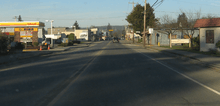
SR 203 begins at a roundabout with SR 202 on the north side of the Snoqualmie River opposite from downtown Fall City. The highway travels northwest along the river, following the eastern ridge of the rural Snoqualmie Valley and the Snoqualmie Valley Trail, and turns north near Pleasant Hill. After passing several farms and a golf course, SR 203 crosses over the Tolt River and enters the city of Carnation. The highway runs northeasterly through downtown Carnation on Tolt Avenue, passing the city library and the historic Tolt IOOF/Eagles Hall before leaving the city. After crossing the Snoqualmie Valley Trail at the Chinook Bend north of Carnation, SR 203 reaches Lake Marcel and turns northwest to follow the Snoqualmie River around Novelty Hill.[2][3]
The highway then turns north and intersects Northeast 124th Street in a roundabout before entering Duvall,[4] where it passes through downtown on Main Street. SR 203 continues northeast across the Cherry Valley and turns northwest before it reaches the Snohomish County line. The highway traverses the Tualco Valley and passes several farms, including one operated by the Monroe Correctional Complex, before crossing over the Skykomish River on a steel truss bridge to enter Monroe.[5] SR 203 travels through Monroe on Lewis Street, passing through residential neighborhoods and the west side of Al Borlin Park before reaching the city's downtown. The highway crosses Main Street and over the Scenic Subdivision of the BNSF Railway before SR 203 terminates at an intersection with US 2.[2][6] The street continues north as Chain Lake Road, while US 2 continues east towards Stevens Pass and west to Snohomish and Everett. The junction is located one mile (1.6 km) west of the Evergreen State Fairgrounds and the terminus of SR 522.[3]
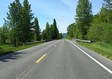
SR 203 is maintained by the Washington State Department of Transportation (WSDOT), which conducts an annual survey on state highways to measure traffic volume in terms of average annual daily traffic. Average traffic volumes on the highway in 2016 ranged from a minimum of 7,200 vehicles near Fall City to a maximum of 14,000 north of Duvall.[7] Most of SR 203 is a rural, soulder-less highway with two lanes and a speed limit of 50 to 55 miles per hour (80 to 89 km/h) outside of city centers.[1][8] A short section of the route within Monroe is also designated as a MAP-21 principal arterial route under the National Highway System.[9]
History
The Snoqualmie Valley was settled in the late 19th century and its communities were originally connected by a series of unpaved country roads. SR 203 was originally four roads that linked each other and their communities, Fall City, Carnation, Duvall and Monroe, named Fall City–Carnation Road, Carnation–Duvall Road, Duvall–Monroe Road and Lewis Street, respectively; these names are still used to identify the route.[2] Lewis Street became the first portion of the highway to be paved when the City of Monroe improved it in 1912.[10] The roads paralleled the former Monroe–Tanner route of the Chicago, Milwaukee, St. Paul and Pacific Railroad.[11] All four roadways were later combined to form Secondary State Highway 15B (SSH 15B) in 1937, during the creation of the Primary and secondary highway system.[12] The Washington State Legislature renumbered and changed the system in 1964 and SSH 15B became SR 203.[13] The highway has changed very little since then. The Tolt River Bridge in Carnation was replaced with a new span in 1977.[14]
In 1998, the Washington State Legislature ordered a $500,000 study to investigate the benefits of constructing the proposed Interstate 605 north to Everett through the Snoqualmie Valley.[15] The plan was dropped as the study found that on average only five minutes would be saved over current routes.[16] In 2002, Bellevue Square owner Kemper Freeman, Jr. made his support known for a new freeway linking Snohomish County via the Snoqualmie Valley.[17] Another $500,000 study was ordered in 2003 by the legislature, creating a new commerce corridor to link Lewis County in the south to the Canada–US border in the north.[18] However the study showed that a highway existing north of I-90 was not economically feasible. Had either proposal been built, it would have essentially replaced highway 203 with an interstate highway.[19]
Recently, smaller projects arranged by the Washington State Department of Transportation (WSDOT) have helped improve traffic on SR 203. Completed in 2004, a roundabout was constructed at the NE 124th Street intersection, located south of Duvall.[20][21]
Major intersections
| County | Location | mi[1] | km | Destinations | Notes |
|---|---|---|---|---|---|
| King | Fall City | 0.00 | 0.00 | Roundabout | |
| Snohomish | Monroe | 23.29– 23.40 | 37.48– 37.66 | Bridge over Skykomish River | |
| 24.26 | 39.04 | ||||
| 1.000 mi = 1.609 km; 1.000 km = 0.621 mi | |||||
References
- 1 2 3 Multimodal Planning Division (January 3, 2018). State Highway Log Planning Report 2017, SR 2 to SR 971 (PDF) (Report). Washington State Department of Transportation. pp. 1146–1155. Retrieved October 14, 2018.
- 1 2 3 Google (October 14, 2018). "State Route 203" (Map). Google Maps. Google. Retrieved October 14, 2018.
- 1 2 Washington State Department of Transportation (2014). Washington State Highways, 2014–2015 (PDF) (Map). Olympia: Washington State Department of Transportation. Puget Sound inset. Retrieved October 14, 2018.
- ↑ Burnham, Michael (October 2, 2004). "Motorists going in circles at roundabout near Duvall". The Seattle Times. p. B2. Retrieved October 14, 2018.
- ↑ Bridge and Structures Office (November 2017). "Bridge List (M 23-09.08)" (PDF). Washington State Department of Transportation. p. 253. Retrieved October 14, 2018.
- ↑ BNSF Subdivisions (PDF) (Map). BNSF Railway. September 1, 2011. Retrieved October 14, 2018.
- ↑ 2016 Annual Traffic Report (PDF) (Report). Washington State Department of Transportation. 2017. p. 162. Retrieved October 14, 2018.
- ↑ Singer, Natalie (September 29, 2004). "Road project offers bypass to conflict". The Seattle Times. p. B4.
- ↑ "State Highway National Highway System Routes in Washington" (PDF). Washington State Department of Transportation. 2017. Retrieved October 14, 2018.
- ↑ Nellie E. Robertson (November 23, 2007). "Monroe – Thumbnail History". HistoryLink. Retrieved May 23, 2009.
Autos and Roads: The push for paving Monroe streets hit high gear in 1912. The council adopted a resolution ordering the pavement of Main and Lewis streets. The resolution provided for parking strips in the center.
- ↑ United States Geological Survey (1948). Wenatchee, 1948 (Map). 1:250,000. Cartography by United States Geological Survey. University of Texas at Austin. Retrieved May 23, 2009.
- ↑ Washington State Legislature (March 18, 1937). "Chapter 207: Classification of Public Highways". Session Laws of the State of Washington. Session Laws of the State of Washington (1937 ed.). Olympia, Washington: Washington State Legislature. p. 1010. Retrieved May 23, 2009.
(b) Secondary State Highway No. 15B; beginning at Monroe on Primary State Highway No. 15, thence in a southerly direction by the most feasible route by way of Duvall to Falls City on Primary State Highway No. 2.
- ↑ C. G. Prahl (December 1, 1965). "Identification of State Highways" (PDF). Washington State Highway Commission, Department of Highways. Retrieved May 23, 2009.
- ↑ "Move planned for Tolt span". The Seattle Times. November 25, 1976. p. A16.
- ↑ Herrinton, Gregg (April 28, 1998). "Interstate 605 Could Help Ease Traffic Mess". The Columbian. p. 1. Retrieved December 14, 2013 – via HighBeam. (Subscription required (help)).
- ↑ Singer, Natalie (July 15, 2004). "State study revives idea of new Western Washington highway". The Seattle Times. The Seattle Times Company. Retrieved November 6, 2010.
- ↑ Gilmore, Susan (August 24, 2003). "Some freeway plans never went anywhere". The Seattle Times. The Seattle Times Company. Retrieved November 6, 2010.
- ↑ Singer, Natalie (July 15, 2004). "State study revives idea of new Western Washington highway". The Seattle Times. The Seattle Times Company. Retrieved November 6, 2010.
- ↑ "Valley will not see proposed foothills highway". Snoqualmie Valley Record. Sound Publishing Inc. October 28, 2004. Retrieved November 6, 2010.
- ↑ Washington State Department of Transportation (2004). "SR 203 – NE 124th/Novelty Road Vicinity – Complete September 2004". Archived from the original on November 19, 2008. Retrieved May 24, 2009.
- ↑ Washington State Department of Transportation (2004). SR 203 – NE 124th/Novelty Hill Road Vicinity (Map). Washington State Department of Transportation. Retrieved May 24, 2009.
External links
Route map: