Warsaw Historic District (Warsaw, Kentucky)
|
Warsaw Historic District | |
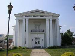 Gallatin County Courthouse | |
 Warsaw Historic District Location in Kentucky  Warsaw Historic District Location in United States | |
| Location | Roughly bounded by W. High, E. Franklin, Washington, Market, Main, 3rd, 4th and Cross Sts., Warsaw, Kentucky |
|---|---|
| Coordinates | 38°46′55″N 84°54′02″W / 38.78194°N 84.90056°WCoordinates: 38°46′55″N 84°54′02″W / 38.78194°N 84.90056°W |
| Area | 65 acres (26 ha) |
| Built | 1820 |
| Architectural style | Italianate, Gothic Revival |
| NRHP reference # | 82002699[1] |
| Added to NRHP | July 29, 1982 |
The Warsaw Historic District, in Warsaw, Kentucky, on the Ohio River, is a 65 acres (26 ha) historic district which was listed on the National Register of Historic Places in 1982. It is roughly bounded by W. High, E. Franklin, Washington, Market, Main, 3rd, 4th and Cross Sts. in Warsaw. The district included 118 contributing buildings.
It includes the Dr. Lucy Dupuy Montz House (at 200 High Street) and the Henry C. Peak House (Sparta Pike) which were listed on the National Register in 1978 and 1980.[1]
The district includes all but eight buildings which were mapped in Warsaw in 1883; a small concentration of buildings on low-lying Locust Street were lost in floods since then.[2]
References
- 1 2 National Park Service (2010-07-09). "National Register Information System". National Register of Historic Places. National Park Service.
- ↑ Robert M. Polsgrove; Rita Bryan, (February 1982). "National Register of Historic Places Inventory/Nomination: Warsaw Historic District". National Park Service. Retrieved March 4, 2018. With 32 photos from 1981.
| Topics | |
|---|---|
| Lists by states |
|
| Lists by insular areas | |
| Lists by associated states | |
| Other areas | |
| |
This article is issued from
Wikipedia.
The text is licensed under Creative Commons - Attribution - Sharealike.
Additional terms may apply for the media files.