Warren Township, Putnam County, Indiana
| Warren Township | |
|---|---|
| Township | |
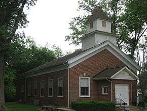 The Putnamville United Methodist Church, a historic place in Warren Township | |
 | |
| Coordinates: 39°34′07″N 86°51′01″W / 39.56861°N 86.85028°WCoordinates: 39°34′07″N 86°51′01″W / 39.56861°N 86.85028°W | |
| Country | United States |
| State | Indiana |
| County | Putnam |
| Government | |
| • Type | Indiana township |
| Area | |
| • Total | 29.02 sq mi (75.2 km2) |
| • Land | 28.98 sq mi (75.1 km2) |
| • Water | 0.04 sq mi (0.1 km2) |
| Elevation[1] | 722 ft (220 m) |
| Population (2010) | |
| • Total | 3,929 |
| • Density | 135.6/sq mi (52.4/km2) |
| Time zone | UTC-5 (Eastern (EST)) |
| • Summer (DST) | UTC-4 (EDT) |
| Area code(s) | 765 |
| FIPS code | 18-80162[2] |
| GNIS feature ID | 453977 |
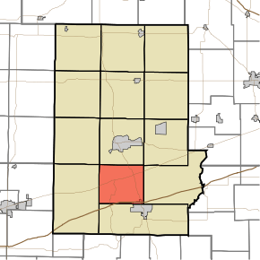
Warren Township is one of thirteen townships in Putnam County, Indiana. As of the 2010 census, its population was 3,929 and it contained 566 housing units.[3]
History
The Putnamville Presbyterian Church was listed on the National Register of Historic Places in 1984.[4]
Geography
According to the 2010 census, the township has a total area of 29.02 square miles (75.2 km2), of which 28.98 square miles (75.1 km2) (or 99.86%) is land and 0.04 square miles (0.10 km2) (or 0.14%) is water.[3]
Cities and towns
- Cloverdale (partial)
Unincorporated towns
- Cradick Corner at 39°32′38″N 86°48′21″W / 39.5439348°N 86.8058415°W
- Jenkinsville at 39°31′58″N 86°52′31″W / 39.5328228°N 86.8752879°W
- Putnamville at 39°34′27″N 86°51′55″W / 39.5742119°N 86.8652875°W
- Westland at 39°35′00″N 86°50′45″W / 39.5833787°N 86.8458424°W
(This list is based on USGS data and may include former settlements.)
References
- ↑ "US Board on Geographic Names". United States Geological Survey. 2007-10-25. Retrieved 2008-01-31.
- ↑ "American FactFinder". United States Census Bureau. Retrieved 2008-01-31.
- 1 2 "Population, Housing Units, Area, and Density: 2010 - County -- County Subdivision and Place -- 2010 Census Summary File 1". United States Census. Retrieved 2013-05-10.
- ↑ National Park Service (2010-07-09). "National Register Information System". National Register of Historic Places. National Park Service.
External links
Municipalities and communities of Putnam County, Indiana, United States | ||
|---|---|---|
| City | ||
| Towns | ||
| Townships | ||
| CDPs | ||
| Other unincorporated communities |
| |
| Footnotes | ‡This populated place also has portions in an adjacent county or counties | |
This article is issued from
Wikipedia.
The text is licensed under Creative Commons - Attribution - Sharealike.
Additional terms may apply for the media files.