War Eagle, West Virginia
| War Eagle | |
|---|---|
| Unincorporated community | |
 War Eagle Location within the state of West Virginia | |
| Coordinates: 37°31′42″N 81°56′38″W / 37.52833°N 81.94389°WCoordinates: 37°31′42″N 81°56′38″W / 37.52833°N 81.94389°W | |
| Country | United States |
| State | West Virginia |
| County | Mingo |
| Elevation | 863 ft (263 m) |
| Time zone | UTC-5 (Eastern (EST)) |
| • Summer (DST) | UTC-4 (EDT) |
| FIPS code | 1555917[1] |
War Eagle is an unincorporated community located in Mingo County, West Virginia.
History
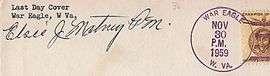
Cancellation from War Eagle
A post office called War Eagle was established in 1902, and remained in operation until it was discontinued in 1959.[2] War Eagle took its name from a local mining company.[3][4]
References
- ↑ U.S. Geological Survey Geographic Names Information System: War Eagle, West Virginia
- ↑ "Mingo County". Jim Forte Postal History. Retrieved 22 April 2015.
- ↑ Scriba, Jay (15 October 1970). "From Sleepy Eye to Chicken Bristle, USA". The Milwaukee Journal. Retrieved 22 April 2015.
- ↑ Kenny, Hamill (1945). West Virginia Place Names: Their Origin and Meaning, Including the Nomenclature of the Streams and Mountains. Piedmont, WV: The Place Name Press. p. 658.
Municipalities and communities of Mingo County, West Virginia, United States | ||
|---|---|---|
| City | 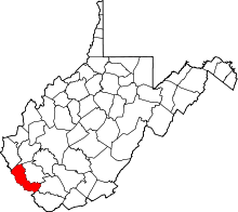 | |
| Towns | ||
| CDPs | ||
| Other communities |
| |
| Footnotes | ‡This populated place also has portions in an adjacent county or counties | |
This article is issued from
Wikipedia.
The text is licensed under Creative Commons - Attribution - Sharealike.
Additional terms may apply for the media files.