Rawl, West Virginia
| Rawl, West Virginia | |
|---|---|
| Unincorporated community | |
 Rawl | |
 Rawl, West Virginia  Rawl, West Virginia | |
| Coordinates: 37°38′59″N 82°13′10″W / 37.64972°N 82.21944°WCoordinates: 37°38′59″N 82°13′10″W / 37.64972°N 82.21944°W | |
| Country | United States |
| State | West Virginia |
| County | Mingo |
| Elevation | 709 ft (216 m) |
| Time zone | UTC-5 (Eastern (EST)) |
| • Summer (DST) | UTC-4 (EDT) |
| ZIP code | 25691 |
| Area code(s) | 304 & 681 |
| GNIS feature ID | 1555446[1] |
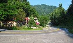
Rawl is an unincorporated community in Mingo County, West Virginia, United States. Rawl is located on the Tug Fork across from Kentucky, 3.5 miles (5.6 km) southeast of Williamson. Rawl has a post office with ZIP code 25691.[2]
References
- ↑ "US Board on Geographic Names". United States Geological Survey. 2007-10-25. Retrieved 2008-01-31.
- ↑ ZIP Code Lookup
Municipalities and communities of Mingo County, West Virginia, United States | ||
|---|---|---|
| City | 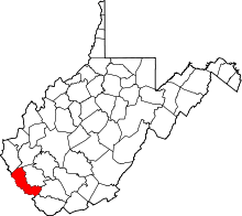 | |
| Towns | ||
| CDPs | ||
| Other communities |
| |
| Footnotes | ‡This populated place also has portions in an adjacent county or counties | |
This article is issued from
Wikipedia.
The text is licensed under Creative Commons - Attribution - Sharealike.
Additional terms may apply for the media files.