Waputik Mountains
| Waputik Mountains | |
|---|---|
 | |
| Highest point | |
| Peak | Howse Peak |
| Elevation | 3,295 m (10,810 ft) |
| Coordinates | 51°48′50″N 116°40′52″W / 51.81389°N 116.68111°W |
| Dimensions | |
| Length | 61 km (38 mi) N-S [1] |
| Width | 40 km (25 mi) E-W [1] |
| Area | 1,069 km2 (413 sq mi) [2] |
| Geography | |
| Country | Canada |
| Province | British Columbia and Alberta |
| Range coordinates | 51°35′N 116°38′W / 51.583°N 116.633°WCoordinates: 51°35′N 116°38′W / 51.583°N 116.633°W [3] |
| Parent range | Canadian Rockies |
| Borders on | Conway Group |
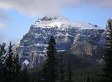
Epaulette Mountain
The Waputik Mountains are a mountain range of the Canadian Rockies, located on the Continental Divide between Banff and Yoho National Park. Covering an area of 1,069 square kilometres (413 sq mi),[2] the range is located west of the Howse, Blaeberry and Amiskwi Rivers and east of the Bow and Mistaya Rivers and south to Kicking Horse Pass.[3]Named in 1884 by George M. Dawson, "waputik" is the Stoney Indian word for white goat.[3]
Many of the highest peaks of the range are heavily glaciated as they sit within the Waputik and Wapta Icefields. The range is further divided into the President Range and Waputik Range
This range includes the following mountains and peaks:[4]
| Mountain | metres | feet |
|---|---|---|
| Howse Peak | 3,295 | 10,810 |
| White Pyramid | 3,275 | 10,745 |
| Mount Balfour | 3,272 | 10,735 |
| Mount Chephren | 3,266 | 10,715 |
| Mount Gordon | 3,203 | 10,508 |
| Mount Baker | 3,172 | 10,407 |
| Mount des Poilus | 3,161 | 10,371 |
| Mount Olive | 3,130 | 10,269 |
| Mount Collie | 3,116 | 10,223 |
| Ayesha Peak | 3,065 | 10,056 |
| Mount Thompson | 3,065 | 10,056 |
| Mount Rhondda | 3,055 | 10,023 |
| Crowfoot Mountain | 3,050 | 10,006 |
| Trapper Peak | 3,014 | 9,888 |
| Peyto Peak | 2,970 | 9,744 |
| St. Nicholas Peak | 2,970 | 9,744 |
| Mount Jimmy Simpson | 2,963 | 9,721 |
See also
References
- 1 2 "Waputik Mountains". Peakbagger.com. Retrieved 2013-06-08.
- 1 2 "Waputik Mountains". bivouac.com. Retrieved 2013-06-08.
- 1 2 3 "Waputik Mountains". BC Geographical Names. Retrieved 2013-06-08.
- ↑ Bow Lake and Saskatchewan Crossing (Map) (2nd ed.). Cochrane, AB: Gem Trek Publishing Ltd.
This article is issued from
Wikipedia.
The text is licensed under Creative Commons - Attribution - Sharealike.
Additional terms may apply for the media files.