Wanakah, New York
| Wanakah, New York | |
|---|---|
| Census-designated place | |
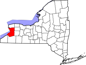
 Location in Erie County and the state of New York. | |
 Wanakah, New York Location in the United States | |
| Coordinates: 42°44′46″N 78°54′11″W / 42.74611°N 78.90306°WCoordinates: 42°44′46″N 78°54′11″W / 42.74611°N 78.90306°W | |
| Country | United States |
| State | New York |
| County | Erie |
| Town | Hamburg |
| Area | |
| • Total | 1.2 sq mi (3.1 km2) |
| • Land | 1.2 sq mi (3.1 km2) |
| • Water | 0 sq mi (0 km2) |
| Elevation | 590 ft (180 m) |
| Population (2010) | |
| • Total | 3,199 |
| • Density | 2,656/sq mi (1,025.5/km2) |
| Time zone | UTC-5 (Eastern (EST)) |
| • Summer (DST) | UTC-4 (EDT) |
| Area code(s) | 716 |
| FIPS code | 36-78124 |
| GNIS feature ID | 0968754 |
Wanakah is a hamlet (and census-designated place) in the town of Hamburg in Erie County, New York, United States.[1] As of the 2010 census, it had a population of 3,199.[2]
Wanakah is part of the Buffalo–Niagara Falls Metropolitan Statistical Area.
Geography
Wanakah is located at 42°44′46″N 78°54′11″W / 42.74611°N 78.90306°W (42.74622, -78.90308) in the western part of the town of Hamburg, on the shore of Lake Erie. The Wanakah CDP encompasses the hamlets of Wanakah, Mount Vernon and Clifton Heights.[3] New York State Route 5 (Lake Shore Road) is the main road through the CDP, leading northeast to Lackawanna and Buffalo and southwest towards Angola.
According to the United States Census Bureau, the CDP has a total area of 1.2 square miles (3.1 km2), all land.[2]
References
- ↑ U.S. Geological Survey Geographic Names Information System: Wanakah, New York
- 1 2 "Geographic Identifiers: 2010 Demographic Profile Data (G001): Wanakah CDP, New York". U.S. Census Bureau, American Factfinder. Retrieved March 28, 2013.
- ↑ "P.L. 94-171 County Block Map series (2010 Census): Erie County, NY". U.S. Census. Retrieved March 29, 2013.