Walnut Township, Atchison County, Kansas
| Walnut Township | |
|---|---|
| Township | |
 Location in Atchison County | |
| Coordinates: 39°27′58″N 095°05′01″W / 39.46611°N 95.08361°WCoordinates: 39°27′58″N 095°05′01″W / 39.46611°N 95.08361°W | |
| Country | United States |
| State | Kansas |
| County | Atchison |
| Area | |
| • Total | 37.2 sq mi (96.4 km2) |
| • Land | 36.3 sq mi (93.9 km2) |
| • Water | 1.0 sq mi (2.5 km2) 2.58% |
| Elevation | 1,024 ft (312 m) |
| Population (2010) | |
| • Total | 441 |
| • Density | 12/sq mi (4.7/km2) |
| GNIS feature ID | 0473513 |
Walnut Township is a township in Atchison County, Kansas, United States. As of the 2010 census, its population was 441.[1]
Geography
Walnut Township covers an area of 37.2 square miles (96.4 km2) and contains no incorporated settlements. According to the USGS, it contains three cemeteries: Mount Gillian, Sapp and Sumner.
The streams of Little Walnut Creek, Owl Creek and Walnut Creek run through this township.
References
- ↑ "Geographic Identifiers: 2010 Demographic Profile Data (G001): Walnut township, Atchison County, Kansas". U.S. Census Bureau, American Factfinder. Retrieved May 13, 2013.
External links
Municipalities and communities of Atchison County, Kansas, United States | ||
|---|---|---|
| Cities | 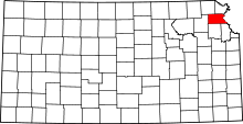 | |
| Unincorporated communities | ||
| Indian reservations | ||
| Townships | ||
| Ghost towns | ||
| Footnotes | ‡This populated place also has portions in an adjacent county or counties | |
This article is issued from
Wikipedia.
The text is licensed under Creative Commons - Attribution - Sharealike.
Additional terms may apply for the media files.