Cummings, Kansas
| Cummings, Kansas | |
|---|---|
| Unincorporated community | |
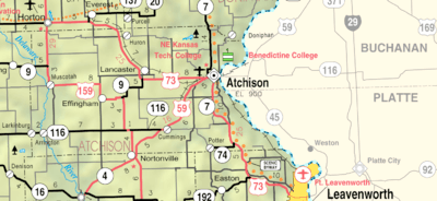 KDOT map of Atchison County (legend) | |
| Coordinates: 39°27′46″N 95°14′51″W / 39.46278°N 95.24750°WCoordinates: 39°27′46″N 95°14′51″W / 39.46278°N 95.24750°W[1] | |
| Country | United States |
| State | Kansas |
| County | Atchison |
| Elevation[1] | 991 ft (302 m) |
| Time zone | UTC-6 (CST) |
| • Summer (DST) | UTC-5 (CDT) |
| ZIP code | 66016 |
| Area code | 913 |
| FIPS code | 20-16750 [1] |
| GNIS ID | 478259 [1] |
Cummings is an unincorporated community in Atchison County, Kansas, United States.[1] Cummings is 9.5 miles (15.3 km) southwest of Atchison. Cummings has a post office with ZIP code 66016.[2]
History
Cummings (formerly Cummingsville) was platted in 1883. It was named for its founder, William Cummings.[3]
References
- 1 2 3 4 5 Geographic Names Information System (GNIS) details for Cummings, Kansas; United States Geological Survey (USGS); October 13, 1978.
- ↑ ZIP Code Lookup Archived 2011-06-15 at the Wayback Machine.
- ↑ Ingalls, Sheffield (1916). History of Atchison County, Kansas. Standard Publishing Company. p. 122.
Municipalities and communities of Atchison County, Kansas, United States | ||
|---|---|---|
| Cities | 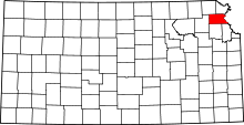 | |
| Unincorporated communities | ||
| Indian reservations | ||
| Townships | ||
| Ghost towns | ||
| Footnotes | ‡This populated place also has portions in an adjacent county or counties | |
This article is issued from
Wikipedia.
The text is licensed under Creative Commons - Attribution - Sharealike.
Additional terms may apply for the media files.