Wakefield Street, Adelaide
| Wakefield Street South Australia | |
|---|---|
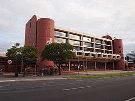 | |
| The Metropolitan Fire Station was built in 1983 | |
| General information | |
| Type | Street |
| Length | 1.2 km (0.7 mi)[1] |
| Opened | 1837 |
| Major junctions | |
| Western end | Victoria Square |
| Pulteney Street, Hutt Street | |
| Eastern end | East Terrace |
Wakefield Street is a main thoroughfare in the centre of the South Australian capital, Adelaide.
It runs in east-west between East Terrace and Victoria Square, and is one of the three streets (along with Grote Street and King William Street) to run through Victoria Square in the middle of the Adelaide city centre. The same three streets are also the widest streets in the city centre, at 2 chains (130 ft; 40 m) wide (refer to Adelaide city centre#Layout).
The western end of Wakefield Street is continued across Victoria Square as Grote Street, which extends to West Terrace. The eastern end of Wakefield Street continues as Wakefield Road across the Adelaide Park Lands to Britannia Roundabout on the City Ring Route, Adelaide. Wakefield Road continues on the eastern side of the roundabout as Kensington Road.
The street was named after Daniel Bell Wakefield, the solicitor who drafted the Act which proclaimed Adelaide. Like his brother Edward Gibbon Wakefield, he was also involved in the South Australia Association in London, but never visited Adelaide.[2]
Businesses, buildings, schools, etc., on Wakefield Street include:
- The Adelaide Metropolitan Fire Service
- St Aloysius College, Adelaide
- St Francis Xavier's Cathedral, Adelaide
- The studios of TV station ADS-10
- Christian Brothers College, Adelaide
- Our Boys' Institute building, now a boutique hotel
The Unitarian Christian Church which once stood opposite Francis Xavier's Cathedral was demolished in 1971 and replaced with a government building "Wakefield Tower".
Junction list
| Location | km[3] | mi | Destinations | Notes | |
|---|---|---|---|---|---|
| Adelaide city centre | 0 | 0.0 | Victoria Square, King William Street | Continues as Grote Street | |
| 0.2 | 0.12 | Gawler Place | |||
| 0.55 | 0.34 | Pulteney Street | |||
| 0.75 | 0.47 | Frome Street | |||
| 1.1 | 0.68 | Hutt Street | |||
| 1.2 | 0.75 | East Terrace | |||
| 1.000 mi = 1.609 km; 1.000 km = 0.621 mi | |||||
See also
![]()
References
- ↑ Google. "Wakefield Street" (Map). Google Maps. Google.
- ↑ "Streets of Adelaide and North Adelaide" (PDF). State Library of South Australia. Retrieved 21 May 2016.
- ↑ Google (11 December 2016). "Wakefield Street, Adelaide" (Map). Google Maps. Google. Retrieved 11 December 2016.
Streets and squares of Adelaide city centre | |||||||||||||
|---|---|---|---|---|---|---|---|---|---|---|---|---|---|
| |||||||||||||