Wagner Township, Clayton County, Iowa
| Wagner Township | |
|---|---|
| Township | |
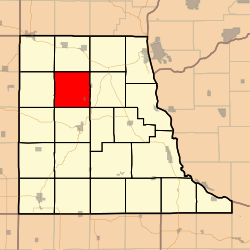 Location in Clayton County | |
| Coordinates: 42°57′25″N 091°25′45″W / 42.95694°N 91.42917°WCoordinates: 42°57′25″N 091°25′45″W / 42.95694°N 91.42917°W | |
| Country |
|
| State |
|
| County | Clayton |
| Area | |
| • Total | 36.44 sq mi (94.37 km2) |
| • Land | 36.44 sq mi (94.37 km2) |
| • Water | 0 sq mi (0 km2) 0% |
| Elevation | 981 ft (299 m) |
| Population (2000) | |
| • Total | 441 |
| • Density | 12.1/sq mi (4.7/km2) |
| GNIS feature ID | 0468878 |
Wagner Township is a township in Clayton County, Iowa, USA. As of the 2000 census, its population was 441.
History
Wagner Township was organized in 1852. It is named for John Wagner, Sr., who settled there in 1846.[1]
Geography
Wagner Township covers an area of 36.44 square miles (94.4 km2) and contains one incorporated settlement, St. Olaf. According to the USGS, it contains nine cemeteries: Clark, Eno, Farmersburg-Wagner, Gooding, Johanningmeier, Norway, Patterson, United Brethren and Weymouth.
The streams of Howard Creek, Silver Creek and Wagner run through this township.
Notes
- ↑ Price, Realto E. (1916). History of Clayton County, Iowa: From the Earliest Historical Times Down to the Present. Robert O. Law Company. p. 323.
References
External links
Municipalities and communities of Clayton County, Iowa, United States | ||
|---|---|---|
| Cities | ||
| Townships | ||
| Unincorporated communities | ||
| Footnotes | ‡This populated place also has portions in an adjacent county or counties | |
This article is issued from
Wikipedia.
The text is licensed under Creative Commons - Attribution - Sharealike.
Additional terms may apply for the media files.