Wagenfelder Aue
| Wagenfelder Aue | |
|---|---|
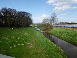 Wagenfelder Aue looking north | |
| Country | Germany |
| States | Lower Saxony |
| Physical characteristics | |
| Main source |
Southern Wagenfeld 52°31′54″N 08°34′24″E / 52.53167°N 8.57333°E |
| River mouth |
Eydelstedt 52°41′42″N 8°31′32″E / 52.6951°N 8.5256°ECoordinates: 52°41′42″N 8°31′32″E / 52.6951°N 8.5256°E |
| Length | 26.3 km (16.3 mi) [1] |
| Basin features | |
| Progression | Hunte→ Weser→ North Sea |
The Wagenfelder Aue is a river of Lower Saxony, Germany, a right tributary of the Hunte. Its total length is 26 kilometres, entirely contained within the southern part of the District of Diepholz. It drains a large area of marshland.
The river rises south of the centre of Wagenfeld and flows northwards through the town, forming the border between the Samtgemeinden (collective municipalities) of Barnstorf and Rehden before discharging into the Hunte south of the town centre of Barnstorf.
See also
References
This article is issued from
Wikipedia.
The text is licensed under Creative Commons - Attribution - Sharealike.
Additional terms may apply for the media files.