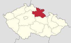
Hradec Králové Region
| Hradec Králové Královéhradecký kraj | |||
|---|---|---|---|
| Region | |||
 | |||
| |||
 | |||
| Country | Czech Republic | ||
| Capital | Hradec Králové | ||
| Districts | Jičín District, Náchod District, Rychnov nad Kněžnou District, Trutnov District | ||
| Government | |||
| • Governor | Jiří Štěpán | ||
| Area | |||
| • Total | 4,758.54 km2 (1,837.28 sq mi) | ||
| Highest elevation | 1,603 m (5,259 ft) | ||
| Population (09/2014) | |||
| • Total | 551,689 | ||
| • Density | 120/km2 (300/sq mi) | ||
| ISO 3166 code | CZ-KR | ||
| Vehicle registration | H | ||
| Website | http://www.kr-kralovehradecky.cz/ | ||
Hradec Králové Region (Czech: Královéhradecký kraj, pronounced [ˈkraːlovɛːˌɦradɛtskiː ˈkraj]; Polish: Kraj hradecki) is an administrative unit (Czech: kraj) of the Czech Republic, located in the north-eastern part of the historical region of Bohemia. It is named after its capital Hradec Králové. The region neighbours the Pardubice Region in the south, the Central Bohemian Region in the south-west, and the Liberec Region in the west. It also shares a 208 km long international border with Polish Lower Silesian Voivodship in the north and the east.
Administrative divisions
After the state administration reform took place (1 January 2000); the Hradec Králové Region is divided into 5 districts:
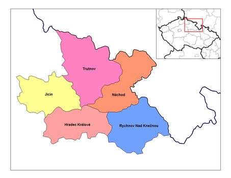 | ||||||||||||
Districts of Hradec Králové Region
| ||||||||||||
As for area, Trutnov District is the largest taking almost one fourth of the entire Region's territory, followed by the Rychnov nad Kněžnou District with 21% and as for the three remaining districts each has about 18%. As of 2003, 15 municipalities with extended powers and 35 municipalities with a delegated municipal office were established in the region.[1]
Population
As of September 2014, the Královéhradecký Region had 551,689 inhabitants, which was 5.3% of the total population of the Czech Republic. With its 116 inhabitants per square kilometer, the region has a lower density than the national average (133 inhabitants per km2). The region has in total 448 independent municipalities, whereof 48 enjoy the status of town. The share of urban population is 67.1%. The region’s centre is Hradec Králové (93,035 inhabitants), followed by Trutnov (30,860 inhabitants) and Náchod (20,417 inhabitants). About one out of eight inhabitants in the region live in a municipality of 500 inhabitants or less. Out of all Czech regions, the Královéhradecký Region has the lowest share of inhabitants aged 15–64 (67%) and the highest share of population aged 65+ (18%). Average age of both men and women is also above the national average.
| Name | Population | Area (km²) | District |
|---|---|---|---|
| 92,904 | 106 | Hradec Králové District | |
| 30,808 | 103 | Trutnov District | |
| 20,417 | 33 | Náchod District | |
| 16,282 | 25 | Jičín District | |
| 15,988 | 36 | Trutnov District | |
| 12,602 | 28 | Trutnov District | |
| 12,594 | 24 | Náchod District | |
| 11,215 | 35 | Rychnov nad Kněžnou District | |
| 9,726 | 23 | Náchod District | |
| 9,213 | 29 | Jičín District | |
| Historical population | ||
|---|---|---|
| Year | Pop. | ±% |
| 1950 | 531,533 | — |
| 1961 | 540,838 | +1.8% |
| 1970 | 540,337 | −0.1% |
| 1980 | 561,385 | +3.9% |
| 1991 | 552,809 | −1.5% |
| 2001 | 550,724 | −0.4% |
| 2014 | 551,689 | +0.2% |
| Source: 1950–2001;[2] 2014[3] | ||
Geography
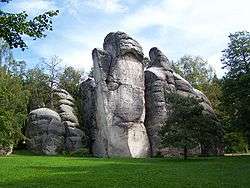
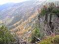
Hradec Králové Region has the area of 4 759 km2 and accounts for 6% of the total area of the Czech Republic. In terms of size it is the ninth largest region of the Czech Republic. Krkonoše and Orlické mountains which are situated in the northern and northeastern part of the region pass to fertile Elbe lowland (Czech: Elbe lowland). Two thirds of the area of the Krkonoše National Park lie within the region’s territory. Krkonoše and Orlické mountains are separated by Broumovský výběžek with its large rock towns – Adršpach-Teplice Rocks, Broumov Hills, Křížový vrch and Ostaš. Main watercourses are Elbe (Czech: Labe) and its tributaries Orlice and Metuje. Almost the entire territory of the region falls into the Elbe’s basin and only a marginal part of the Broumovský výběžek area falls under the basin of the River Oder (Czech: Odra). Sněžka mountain is with its elevation of 1603 m above sea level the highest point of the region, Krkonoše mountains and also of the Czech Republic. The lowest point of the region is the surface of the River Cidlina (202 m above sea level).[1]
Economy
In terms of economic activities, the region can be described as agricultural-industrial with well-developed tourism. The region is part of the so-called Black Triangle, an area of heavily industrialization and environmental damage on the three-way border of Poland, Germany, and the Czech Republic.[4] The industry is concentrated in big towns while the agriculture in the Elbe lowland (Czech: Polabí). The tourism is concentrated in Krkonoše. In 2012, the gross domestic product of Hradec Králové Region accounted for about 4.5% of the total GDP of the Czech Republic. Region’s GDP per capita amounted to 85.7% of national average and ranked as the fourth highest. As of September 2014, the unemployment rate in the region was 5.9%. The average gross salary was 22,842 CZK.
According to Labour Force Survey, there were in total about 253,200 employees in the region in 2012. Hereof, the largest proportion (31.1%) worked in manufacturing, followed by trade and repair of personal and household goods (12.2%), health and social care (7.9%), construction (7.3%), public administration and defence (6.5%), transportation and storage (5.9%), etc.
Manufacturing prevails over the other industries and focuses on motor vehicles, electrical equipment and textiles. However, Hradec Králové Region does not rank among key industrial areas – its 2012 share in sales of industrial enterprises accounted for 3.8% of the national’s total. With regard to agriculture, crop production focuses on cereals (wheat and barley), rape and maize, with industrial sugar beet production playing an important role too. Animal production focuses on raising cattle and pigs. About 4.1% of region's workforce worked in agriculture, forestry and fishing in 2012. As of 2012, agricultural land covered 58% of the total region's territory and the share of arable land was 40%, while forests covered 31% of the territory.
In 2012, the 954 statistically monitored collective accommodation establishments in the region reported 887,000 guests, including about 213,000 foreigners coming especially from Germany, Poland and the Netherlands. The average length of stays per guest was 4.5 days. During the last few years, many forms of cross-border co-operation have been developed. One of them is the Glacensis Euroregion that had been established in 1995 as one of the Euroregions covering the Czech-Polish border areas.[1]
Places of interest
Photo gallery
 Adršpach-Teplice Rocks from air
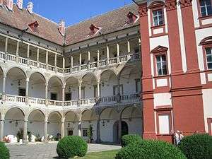
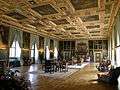 Knight's hall in Častolovice castle
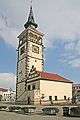

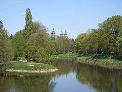
 The Elbe valley
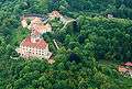 Castle in Náchod
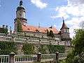
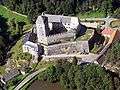
 Castle in Opočno
References
- 1 2 3 "Obsah nenalezen - ČSÚ". www.czso.cz.
- ↑ http://mapy.kr-kralovehradecky.cz/prumzony/cz/pracovni-sila.htm accessdate=December 20, 2014
- ↑ http://notes.czso.cz/xh/redakce.nsf/i/home%7Caccessdate=December 20, 2014
- ↑ "Archived copy" (PDF). Archived from the original (PDF) on 2014-04-13. Retrieved 2014-04-16. page 9