Vulcan's Thumb
| Vulcan's Thumb | |
|---|---|
 | |
| Highest point | |
| Elevation | 2,290 m (7,510 ft) |
| Coordinates | 50°06′41.06″N 123°17′40.22″W / 50.1114056°N 123.2945056°W |
| Geography | |
| Location | British Columbia, Canada |
| Parent range | Pacific Ranges |
| Topo map | NTS 92J/03 |
| Geology | |
| Age of rock | Pleistocene |
| Mountain type | Pinnacle |
| Volcanic arc/belt |
Canadian Cascade Arc Garibaldi Volcanic Belt |
| Climbing | |
| First ascent | None |
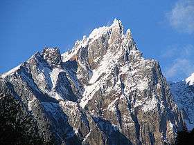
The Vulcan's Thumb is a rock pinnacle in the Pacific Ranges of southwestern British Columbia, Canada. It is the largest of a number of slender pinnacles protruding from the sharp summit ridge of Pyroclastic Peak, which forms part of the Mount Cayley massif.[1]
Three eruptive stages built the Mount Cayley massif, the second of which is named after the Vulcan's Thumb.[1]
See also
References
- 1 2 Kelman, M. C., Russell, J. K., Hickson, C. J. (2001). "Preliminary petrography and chemistry of the Mount Cayley volcanic field, British Columbia", Current Research Part A, Geological Survey of Canada Paper 2001-A11, pp. 4, 5.
This article is issued from
Wikipedia.
The text is licensed under Creative Commons - Attribution - Sharealike.
Additional terms may apply for the media files.