Blanshard Peak
| Blanshard Peak (Blanshard Needle) | |
|---|---|
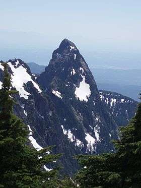 Blanshard Peak seen from near the summit of Golden Ears (mountain) | |
| Highest point | |
| Elevation | 1,550 m (5,090 ft) |
| Prominence | 170 m (560 ft) |
| Coordinates | 49°20′36″N 122°30′00″W / 49.34333°N 122.50000°WCoordinates: 49°20′36″N 122°30′00″W / 49.34333°N 122.50000°W |
| Geography | |
| Location | British Columbia, Canada |
| Parent range | Garibaldi Ranges |
| Topo map | NTC 92G/14 |
| Climbing | |
| First ascent | 1918 P. James, Don Munday, M. Worsley[1] |
| Easiest route | 30 m of 5th class, 4th class scramble[1] |
Blanshard Peak also known as The Blanshard Needle by local climbers[2] is a distinctive rock pinnacle in Golden Ears Provincial Park that is visible from many places in the Lower Mainland. Named for the first governor of the colony of Vancouver Island, the name of the summit and area is the subject of some confusion due to the labeling of the entire Golden Ears Group on the published maps for the area.[3][4] Mount Blanshard is the proper name of the Golden Ears massif, and later became attached by authors of climbing guides to the summit at the southern end of the group.[2]
See also
Notes
References
- "Blanshard Peak". Canadian Mountain Encyclopedia. Archived from the original on 2007-03-22. Retrieved 2007-02-18.
- Ricker, Karl (1983). Canadian Alpine Journal. 66: 40–43. Missing or empty
|title=(help) - Canada Centre for Mapping (1992), Stave Lake 92G/08 Edition 4, Department of Energy Mines and Resources
- Canada Centre for Mapping (1999), Port Coquitlam 92G/07 Edition 5, Department of Energy Mines and Resources
External links
- "Blanshard Peak". BC Geographical Names.
- "Blanshard Peak". Bivouac.com.
This article is issued from
Wikipedia.
The text is licensed under Creative Commons - Attribution - Sharealike.
Additional terms may apply for the media files.