Coquitlam Mountain
| Coquitlam Mountain | |
|---|---|
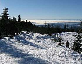 View from Burke Mountain on the southern ridge of Coquitlam Mountain. | |
| Highest point | |
| Elevation | 1,583 m (5,194 ft) [1] |
| Prominence | 698 m (2,290 ft) [1] |
| Coordinates | 49°23′34″N 122°42′25″W / 49.39278°N 122.70694°WCoordinates: 49°23′34″N 122°42′25″W / 49.39278°N 122.70694°W[2] |
| Geography | |
| Location | Coquitlam, British Columbia |
| Parent range | Pacific Ranges |
| Topo map | NTS 92G/07[2] |
Coquitlam Mountain is a mountain located in northeast Coquitlam, British Columbia, 6.2 km (3.9 mi) east of Coquitlam Lake and 9.7 km (6.0 mi) north of Minnekhada Regional Park. The mountain is located at the head of Or Creek, completely within the Coquitlam watershed, and thus public access is forbidden by law. Mount Burke forms the southern ridge of Coquitlam Mountain.[1]
The first recorded ascent of the mountain was in 1918 by P. James and D. Munday.[1] The mountain's name was adopted on 3 May 1951, in association with the Coquitlam River.[2]
References
- 1 2 3 4 "Coquitlam Mountain". Bivouac.com.
- 1 2 3 "Coquitlam Mountain". BC Geographical Names. Retrieved 4 March 2009.
This article is issued from
Wikipedia.
The text is licensed under Creative Commons - Attribution - Sharealike.
Additional terms may apply for the media files.