Vražkov
| Vražkov | |||
|---|---|---|---|
| Municipality | |||
 | |||
| |||
 Vražkov | |||
| Coordinates: 50°22′22″N 14°16′6″E / 50.37278°N 14.26833°ECoordinates: 50°22′22″N 14°16′6″E / 50.37278°N 14.26833°E | |||
| Country |
| ||
| Region | Ústí nad Labem | ||
| District | Litoměřice | ||
| Area | |||
| • Total | 7.62 km2 (2.94 sq mi) | ||
| Elevation | 205 m (673 ft) | ||
| Population (2007) | |||
| • Total | 413 | ||
| • Density | 54/km2 (140/sq mi) | ||
| Postal code | 411 84 | ||
| Website | http://mesta.obce.cz/web/index.asp?u=18574 | ||

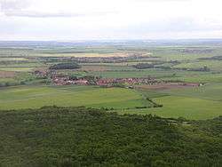
Vražkov is a village and municipality (obec) in Litoměřice District in the Ústí nad Labem Region of the Czech Republic.
The municipality covers an area of 7.62 square kilometres (2.94 sq mi), and has a population of 413 (as at 31 December 2007).
Vražkov lies approximately 21 kilometres (13 mi) south-east of Litoměřice, 36 km (22 mi) south-east of Ústí nad Labem, and 34 km (21 mi) north of Prague.
References
| Wikimedia Commons has media related to Vražkov. |
This article is issued from
Wikipedia.
The text is licensed under Creative Commons - Attribution - Sharealike.
Additional terms may apply for the media files.