Horní Beřkovice
| Horní Beřkovice | |||
|---|---|---|---|
| Municipality | |||
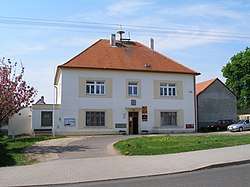 Municipal office | |||
| |||
 Horní Beřkovice | |||
| Coordinates: 50°21′34″N 14°21′8″E / 50.35944°N 14.35222°ECoordinates: 50°21′34″N 14°21′8″E / 50.35944°N 14.35222°E | |||
| Country |
| ||
| Region | Ústí nad Labem | ||
| District | Litoměřice | ||
| Area | |||
| • Total | 5.09 km2 (1.97 sq mi) | ||
| Elevation | 210 m (690 ft) | ||
| Population (2007) | |||
| • Total | 890 | ||
| • Density | 170/km2 (450/sq mi) | ||
| Postal code | 411 85 | ||
| Website | http://www.obechorniberkovice.cz | ||
Horní Beřkovice (German: Ober Berschkowitz) is a village and municipality (obec) in Litoměřice District in the Ústí nad Labem Region of the Czech Republic.
The municipality covers an area of 5.09 square kilometres (1.97 sq mi), and had a population of 890 as of 31 December 2007.
Horní Beřkovice lies approximately 26 kilometres (16 mi) south-east of Litoměřice, 40 km (25 mi) south-east of Ústí nad Labem, and 31 km (19 mi) north of Prague.
The village contains a former mental institution, now the municipal office, and a firing range for the police.
People
- Klementina Kalašová, Czech opera singer
References
| Wikimedia Commons has media related to Horní Beřkovice. |
This article is issued from
Wikipedia.
The text is licensed under Creative Commons - Attribution - Sharealike.
Additional terms may apply for the media files.