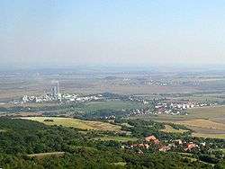
Čížkovice
| Čížkovice | |||
|---|---|---|---|
| Municipality | |||
 | |||
| |||
 Čížkovice | |||
| Coordinates: 50°29′2″N 14°1′52″E / 50.48389°N 14.03111°ECoordinates: 50°29′2″N 14°1′52″E / 50.48389°N 14.03111°E | |||
| Country |
| ||
| Region | Ústí nad Labem | ||
| District | Litoměřice | ||
| Area | |||
| • Total | 7.05 km2 (2.72 sq mi) | ||
| Elevation | 175 m (574 ft) | ||
| Population (2007) | |||
| • Total | 1,335 | ||
| • Density | 190/km2 (490/sq mi) | ||
| Postal code | 411 12 | ||
| Website | http://www.cizkovice.cz | ||


Čížkovice (German Tschischkowitz) is a village and municipality (obec) in Litoměřice District in the Ústí nad Labem Region of the Czech Republic.
The municipality covers an area of 7.05 square kilometres (2.72 sq mi), and has a population of 1,335 (as at 31 December 2007). Apart from the village of Čížkovice itself, the municipality also includes the village of Želechovice.
Čížkovice lies approximately 9 kilometres (6 mi) south-west of Litoměřice, 20 km (12 mi) south of Ústí nad Labem, and 53 km (33 mi) north-west of Prague. It is about 3.5 km southwest of Lovosice.
References
| Wikimedia Commons has media related to Čížkovice. |
This article is issued from
Wikipedia.
The text is licensed under Creative Commons - Attribution - Sharealike.
Additional terms may apply for the media files.