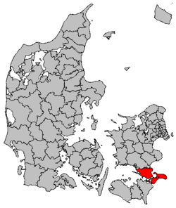
Vordingborg Municipality
| Vordingborg Municipality Vordingborg Kommune | ||
|---|---|---|
| Municipality | ||
| ||
 | ||
| Country | Denmark | |
| Region | Region Zealand | |
| Seat | Vordingborg | |
| Government | ||
| • Mayor | Knud Larsen (V) | |
| Area | ||
| • Total | 621.0 km2 (239.8 sq mi) | |
| Population (1 January 2012) | ||
| • Total | 45,925 | |
| • Density | 74/km2 (190/sq mi) | |
| Time zone | UTC+1 (CET) | |
| • Summer (DST) | UTC+2 (CEST) | |
| Municipal code | 390 | |
| Website | www.vordingborg.dk | |
Vordingborg is a municipality (kommune) in the Sjælland Region, which is on the southeast coast of the island of Zealand (Sjælland) in south Denmark. It was established in 2007. The municipality includes the island of Masnedø, and covers an area of 621 km². It has a total population of 46,600 (2006). Its second and current mayor is Knud Larsen of the agrarian-liberal Venstre party, who was elected in 2007 replacing Henrik Holmer of the Social Democrats.
The municipality takes its name from the town of the same name.
Overview
The Masnedsund Bridge connects the town of Vordingborg to the island of Masnedø. The Storstrøm Bridge connects Masnedø to the neighboring municipality of Guldborgsund on Falster near the town of Orehoved. The bridge is 3,199 meters long and supports two lanes of traffic and a single-track railway. It was inaugurated in 1937.
The Farø Bridges (The Farø High Bridge and the Farø Low Bridge) opened in 1985 and connect the two municipalities from the town of Bakkebølle Strand over Farø island (part of former Møn municipality) to Falster near the town of Sortsøgab. Bogø island is also part of the municipality.
As part of wider municipal reforms, an earlier Vordingborg municipality was merged with its neighboring municipalities of Langebæk, Møn, and Præstø on 1 January 2007, forming the enlarged Vordingborg Municipality.
Around 135 km (84 mi) east of Vordingborg municipality across the Baltic Sea is Bornholm, the easternmost municipality of Denmark, which is a part of the Capital Region of Denmark.
For the location of Vordingborg municipality relative to its neighbors, see the location diagram at the bottom of the corresponding article on Danish language Wikipedia, Vordingborg Kommune.
Urban areas
The ten largest urban areas in the municipality are:
| # | Locality | Population |
|---|---|---|
| 1 | Vordingborg | 11,643 |
| 2 | Præstø | 3,853 |
| 3 | Stege | 3,835 |
| 4 | Nyråd | 2,479 |
| 5 | Ørslev | 1,870 |
| 6 | Stensved | 1,548 |
| 7 | Køng | 987 |
| 8 | Mern | 957 |
| 9 | Bogø By | 869 |
| 10 | Gammel Kalvehave | 832 |
See also
References
- Municipal statistics: NetBorger Kommunefakta, delivered from KMD aka Kommunedata (Municipal Data)
- Municipal mergers and neighbors: Eniro new municipalities map
External links
| Wikimedia Commons has media related to Vordingborg Kommune. |
Coordinates: 55°00′30″N 11°54′37″E / 55.00833°N 11.91028°E