Vontimitta
| Vontimitta | |
|---|---|
| Temple Town | |
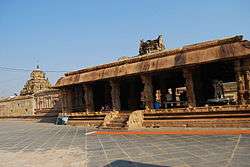 View of the Sri Kodandarama Swamy Temple in Vontimitta | |
 Vontimitta Location in Andhra Pradesh, India  Vontimitta Vontimitta (India) | |
| Coordinates: 14°23′00″N 79°02′00″E / 14.3833°N 79.0333°ECoordinates: 14°23′00″N 79°02′00″E / 14.3833°N 79.0333°E | |
| Country | India |
| State | Andhra Pradesh |
| Region | Rayalaseema |
| District | Kadapa |
| Government | |
| • ZPTC | Eragamreddy subbareddy (zp-vicechairman) |
| • ruling party | YSRCONGRESS |
| Population (2011) | |
| • Total | 16,067 |
| Languages | |
| Time zone | UTC+5:30 (IST) |
| PIN | 516213 |
| Telephone code | 08589 |
| Vehicle registration | AP-04 |
Vontimitta is a village in Kadapa district of the Indian state of Andhra Pradesh. It is located in Vontimitta mandal of Rajampeta revenue division.[1]
Geography
Ontimitta is located at 14°23′00″N 79°02′00″E / 14.3833°N 79.0333°E.[2] It has an average elevation of 151 meters (498 feet).
See also
References
- ↑ "Revenue Divisions and Mandals". Official website of YSR Kadapa District. National Informatics Centre- Kadapa, Andhra Pradesh. Retrieved 23 May 2015.
- ↑ "Falling Rain Genomics.Ontimitta". Fallingrain.com. Retrieved 2012-03-11.
Template:Contact jeeevan rayudu
This article is issued from
Wikipedia.
The text is licensed under Creative Commons - Attribution - Sharealike.
Additional terms may apply for the media files.