Vitória do Jari
| Vitória do Jari | ||
|---|---|---|
| Municipality | ||
| The Municipality of Vitória do Jari | ||
| ||
| Nickname(s): "Beiradinho" | ||
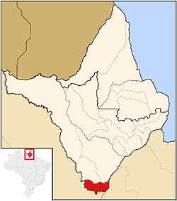 Location of Vitória do Jari in the State of Amapá | ||
| Coordinates: 01°07′25″S 51°59′45″W / 1.12361°S 51.99583°WCoordinates: 01°07′25″S 51°59′45″W / 1.12361°S 51.99583°W | ||
| Country |
| |
| Region | North | |
| State |
| |
| Founded | September 8, 1994 | |
| Government | ||
| • Mayor | Raimundo de Alcimar Ney de Souza (PT) | |
| Area | ||
| • Total | 2,509 km2 (969 sq mi) | |
| Elevation | 3 m (10 ft) | |
| Population (2016) | ||
| • Total | 14,680 | |
| • Density | 5.9/km2 (15/sq mi) | |
| [1] | ||
| Time zone | UTC-3 (UTC-3) | |
| HDI (2000) | 0.659 – medium[2] | |

Vitória do Jari (Jari's Victory) is a municipality located in the southernmost tip of the state of Amapá in Brazil. Its population is 14,680 and its area is 2,509 km2 (969 sq mi). Vitória do Jari has a population density of 5.9 inhabitants per square kilometer.
The municipality contains 17% of the 501,771 hectares (1,239,900 acres) Rio Cajari Extractive Reserve, created in 1990.[3]
References
- ↑ "Vitória do Jari" (in Portuguese). Brasília, Brazil: Instituto Brasileiro de Geografia e Estatística. 2016. Retrieved 2016-10-29.
- ↑ UNDP
- ↑ RESEX do Rio Cajari (in Portuguese), ISA: Instituto Socioambiental, retrieved 2016-11-06
Capital: Macapá | ||
| Amapá | 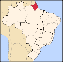 | |
| Macapá | ||
| Mazagão | ||
| Oiapoque | ||
This article is issued from
Wikipedia.
The text is licensed under Creative Commons - Attribution - Sharealike.
Additional terms may apply for the media files.